1960s Maps of Nebraska City, Nebraska
Explore 2 historic maps of Nebraska City from the 1960s. These maps offer a rare glimpse into what life looked like during the 1960s — showing old roads, neighborhoods, homes, and landmarks that have changed or disappeared over time.
Whether you're researching your family's past, planning a metal detecting trip, or studying how Nebraska City's landscape evolved across the 1960s, these high-resolution maps are a powerful tool for exploring the history of this region.
- Focus on a specific era: All maps on this page are from the 1960s, giving you a focused view of this time period.
- See what’s changed: Compare century-old streets, trails, and buildings to today's modern landscape using overlays and satellite layers.
- Research with precision: Use these maps for genealogy, historical research, land use analysis, or educational projects.
- View, download, or print: Maps are fully viewable online in high resolution, and can be downloaded or printed for your own records.
Start exploring Nebraska City's history through authentic maps from the 1960s. This is your window into the past.
Nebraska City, NE maps
(2)- 1966 Map of Nebraska City NW, 1967 Print
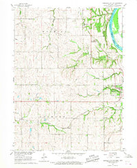 1966 Nebraska City NW1967 Print · USGSOtoe County at the height of the 1960s reveals a landscape shaped by historic transit and rural school districts. Genealogists and historians can trace the Steam Wagon Road, locate family-named sites like Cowles Cem, and see the early layout of Arbor Lodge State Park.
 - 1966 Map of Nebraska City, 1968 Print
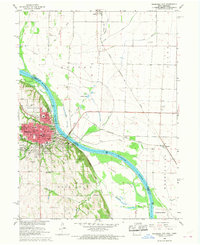 1966 Nebraska City1968 Print · USGSNebraska City and the Missouri River bottoms are captured here in the mid-sixties as the region's rail and agricultural networks remained in full swing. Researchers can trace family sites at Wyuka Cemetery, St Marys Cem, and local institutions like St Mary Hospital.2 unique versions available
End of results
Showing maps 1-2 of 2
Top cities near Nebraska City
- Sidney historical maps
- Tabor historical maps
- Hamburg historical maps
- Peru historical maps
- Talmage historical maps
- Union historical maps
See more
Top neighborhoods of Nebraska City
Frequently asked questions
- What are the different types of historical maps available for Nebraska City?
- What is the oldest map of Nebraska City?
- Where can I purchase historical maps of Nebraska City for my home or office?
- Where can I download high-res historical maps of Nebraska City?
- Are there historical topographic maps available for Nebraska City?
- Is there historical aerial imagery available for Nebraska City?
- Where are historical maps of Nebraska City sourced from?