1900s (20th Century) Maps of Madrid, Nebraska
Explore 6 historic maps of Madrid from the 1900s (20th Century). These maps offer a rare glimpse into what life looked like during the 1900s — showing old roads, neighborhoods, homes, and landmarks that have changed or disappeared over time.
Whether you're researching your family's past, planning a metal detecting trip, or studying how Madrid's landscape evolved across the 1900s, these high-resolution maps are a powerful tool for exploring the history of this region.
- Focus on a specific era: All maps on this page are from the 1900s, giving you a focused view of this time period.
- See what’s changed: Compare century-old streets, trails, and buildings to today's modern landscape using overlays and satellite layers.
- Research with precision: Use these maps for genealogy, historical research, land use analysis, or educational projects.
- View, download, or print: Maps are fully viewable online in high resolution, and can be downloaded or printed for your own records.
Start exploring Madrid's history through authentic maps from the 1900s. This is your window into the past.
Madrid, NE maps
(6)- 1954 Map of McCook, 1966 Print
 1954 McCook1966 Print · USGSSouthwest Nebraska in the mid-fifties reveals a landscape shaped by major water projects and the Chicago Burlington and Quincy RR. Trace ancestral roots and defunct rail stops in McCook, Wauneta, and along the shores of Swanson Lake.2 unique versions available
 - 1957 Map of McCook
 1957 McCook1957 Print · USGSSouthwestern Nebraska in the mid-fifties is captured here during a period of significant water development and rail-based commerce. Researchers can trace the path of the Chicago Burlington and Quincy through Indianola and Bartley, or locate rural settlements like Chase Village and Ough near the Sand Hills.
 - 1958 Map of McCook
 1958 McCook1958 Print · USGSSouthwest Nebraska during the late fifties reveals a landscape of massive new reservoirs and established rail hubs like McCook. Genealogists can trace family footprints through rural centers like St Johns Church and the many grain elevators along the Union Pacific RR.2 unique versions available
 - 1973 Map of Elsie, 1977 Print
 1973 Elsie1977 Print · USGSPerkins County in the early 1970s is shown as an agricultural landscape centered on the village of Elsie. Local historians can trace the path of the Burlington Northern railroad and the natural course of Stinking Water Creek across the high plains.
 - 1973 Map of Madrid, 1977 Print
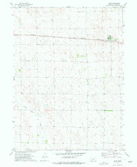
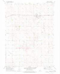 1973 Madrid1977 Print · USGSMadrid and the surrounding Perkins County plains are captured here in the early 1970s as a landscape of rail-linked agriculture. Genealogists and local historians can trace the town grid of Madrid, locate the local Cem, and follow the path of the Burlington Northern railroad.
 - 1979 Map of Imperial
 1979 Imperial1979 Print · USGSThe high plains of southwest Nebraska are captured here in the late seventies, showing a landscape defined by rail corridors and creek draws. Genealogists can trace family names and sites through Imperial, Wallace, and Hayes Center, or locate rural landmarks like Arterburn Lake.
End of results
Showing maps 1-6 of 6
Top cities near Madrid
Frequently asked questions
- What are the different types of historical maps available for Madrid?
- What is the oldest map of Madrid?
- Where can I purchase historical maps of Madrid for my home or office?
- Where can I download high-res historical maps of Madrid?
- Are there historical topographic maps available for Madrid?
- Is there historical aerial imagery available for Madrid?
- Where are historical maps of Madrid sourced from?