1970s Maps of Bertrand, Nebraska
Explore 2 historic maps of Bertrand from the 1970s. These maps offer a rare glimpse into what life looked like during the 1970s — showing old roads, neighborhoods, homes, and landmarks that have changed or disappeared over time.
Whether you're researching your family's past, planning a metal detecting trip, or studying how Bertrand's landscape evolved across the 1970s, these high-resolution maps are a powerful tool for exploring the history of this region.
- Focus on a specific era: All maps on this page are from the 1970s, giving you a focused view of this time period.
- See what’s changed: Compare century-old streets, trails, and buildings to today's modern landscape using overlays and satellite layers.
- Research with precision: Use these maps for genealogy, historical research, land use analysis, or educational projects.
- View, download, or print: Maps are fully viewable online in high resolution, and can be downloaded or printed for your own records.
Start exploring Bertrand's history through authentic maps from the 1970s. This is your window into the past.
Bertrand, NE maps
(2)- 1970 Map of Bertrand SE, 1972 Print
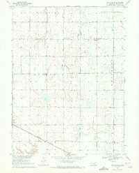 1970 Bertrand SE1972 Print · USGSThe Phelps County plains in the early seventies show a landscape of intensive irrigation and rail transport. Researchers can locate the Sandstrom Cem and trace the Burlington Northern tracks as they pass through Bertrand.
 - 1971 Map of Bertrand, 1973 Print
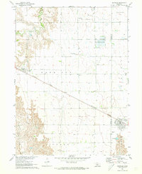 1971 Bertrand1973 Print · USGSThe border of Phelps and Gosper Counties comes into focus in the early seventies, showing a landscape of Nebraska prairie and vital irrigation. Researchers can trace the Burlington Northern rail line connecting Smithfield and Bertrand, or find family names near Highland Cem.
End of results
Showing maps 1-2 of 2
Top cities near Bertrand
- Lexington historical maps
- Elwood historical maps
- Overton historical maps
- Loomis historical maps
- Westmark historical maps
- Atlanta historical maps
See more
Frequently asked questions
- What are the different types of historical maps available for Bertrand?
- What is the oldest map of Bertrand?
- Where can I purchase historical maps of Bertrand for my home or office?
- Where can I download high-res historical maps of Bertrand?
- Are there historical topographic maps available for Bertrand?
- Is there historical aerial imagery available for Bertrand?
- Where are historical maps of Bertrand sourced from?