1970s Maps of Holdrege, Nebraska
Explore 2 historic maps of Holdrege from the 1970s. These maps offer a rare glimpse into what life looked like during the 1970s — showing old roads, neighborhoods, homes, and landmarks that have changed or disappeared over time.
Whether you're researching your family's past, planning a metal detecting trip, or studying how Holdrege's landscape evolved across the 1970s, these high-resolution maps are a powerful tool for exploring the history of this region.
- Focus on a specific era: All maps on this page are from the 1970s, giving you a focused view of this time period.
- See what’s changed: Compare century-old streets, trails, and buildings to today's modern landscape using overlays and satellite layers.
- Research with precision: Use these maps for genealogy, historical research, land use analysis, or educational projects.
- View, download, or print: Maps are fully viewable online in high resolution, and can be downloaded or printed for your own records.
Start exploring Holdrege's history through authentic maps from the 1970s. This is your window into the past.
Holdrege, NE maps
(2)- 1970 Map of Holdrege East, 1972 Print
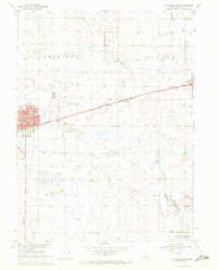 1970 Holdrege East1972 Print · USGSPhelps County, Nebraska, is seen here in the early 1970s as its rail-centered agricultural economy thrives. Researchers can trace the layout of HOLDREGE, locate rural landmarks like School No 7, and explore cemeteries such as Prairie Home.
 - 1970 Map of Holdrege West, 1972 Print
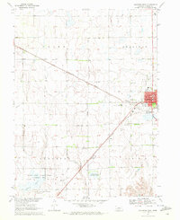 1970 Holdrege West1972 Print · USGSPhelps County was thriving in the early 1970s as the rail lines and agricultural industry shaped the landscape west of the county seat. Genealogists and researchers can trace local landmarks like Industry Cem, Washington Sch, and the Home for the Aged.
End of results
Showing maps 1-2 of 2
Top cities near Holdrege
- Loomis historical maps
- Wilcox historical maps
- Westmark historical maps
- Funk historical maps
- Atlanta historical maps
- Huntley historical maps
See more
Top neighborhoods of Holdrege
Frequently asked questions
- What are the different types of historical maps available for Holdrege?
- What is the oldest map of Holdrege?
- Where can I purchase historical maps of Holdrege for my home or office?
- Where can I download high-res historical maps of Holdrege?
- Are there historical topographic maps available for Holdrege?
- Is there historical aerial imagery available for Holdrege?
- Where are historical maps of Holdrege sourced from?