Old Maps of Speer Ranch, Nebraska for Academic Research
Study the evolution of Speer Ranch with 11 high-resolution historic maps. Whether you're teaching, researching, or modeling changes in land use, these maps provide essential visual documentation of urban, environmental, and geographic change.
- Analyze long-term change: Track patterns in development, transportation, and natural features.
- Ideal for environmental or urban studies: Support academic projects with primary historical map data.
- Use in the classroom or lab: Educators and researchers rely on these maps to bring historical context to life.
These maps are a powerful tool for teaching, research, and visualizing how Speer Ranch has changed over the decades.
Speer Ranch, NE maps
(11)- 1948 Map of Twin Lakes, 1976 Print
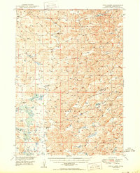
 1948 Twin Lakes1976 Print · USGSSheridan County ranching country is captured here in the late forties, showing a landscape of remote valleys and scattered windmills. Genealogists can trace rural school districts like North Sch No 165 or the location of Spring Lake Camp.
 - 1950 Map of Twin Lakes
 1950 Twin Lakes1950 Print · USGSSheridan County's high plains and marshy basins are captured here at mid-century, documenting a landscape of isolated ranching outposts and rural districts. Genealogists can trace family footprints through numerous local landmarks like North Sch No 165, Spring Lake Camp, and Diamond Lake.2 unique versions available
 - 1955 Map of Alliance, 1966 Print
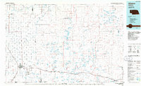
 1955 Alliance1966 Print · USGSThe Nebraska panhandle comes into sharp focus during the mid-fifties, showing a landscape defined by the Niobrara River and the expanding Sand Hills. Researchers can trace the grounds of Fort Robinson, locate Saint Marys Church, or follow the Chicago Burlington and Quincy rail line through Hemingford.3 unique versions available
 - 1957 Map of Alliance
 1957 Alliance1957 Print · USGSNorthwest Nebraska in the mid-fifties is captured here as a landscape of rail hubs, sprawling cattle ranches, and the eastern edge of the dunes. Genealogists and historians can trace rail lines through Alliance and Chadron or locate landmarks like Saint Marys Church and the Agate Spring Fossil Beds.
 - 1958 Map of Alliance
 1958 Alliance1958 Print · USGSNorthwestern Nebraska in the late fifties shows a landscape shaped by the legacy of the high plains frontier and modern agricultural expansion. Genealogists and historians can trace rail-line settlements and landmarks like Fort Robinson and the Agate Spring Fossil Beds.
 - 1985 Map of Alliance, 1986 Print
 1985 Alliance1986 Print · USGSThe High Plains of Box Butte and Sheridan counties come alive in the mid-1980s, centered on the rail hub of Alliance. Genealogists and historians can trace the Burlington Northern line through small sidings and towns like Antioch, Lakeside, and Bingham near the Niobrara River.2 unique versions available
 - 1989 Map of Twin Lakes
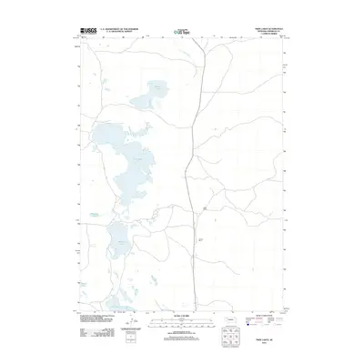
 1989 Twin Lakes1989 Print · USGSSheridan County ranching country is documented here in the late eighties, showing a landscape defined by the Nebraska Sandhills water system. Genealogists can locate family landmarks like Speer Ranch and Hopper Ranch or the rural Sch No 127.
 - 2011 Map of Twin Lakes, 2011 Print
 2011 Twin Lakes2011 Print · USGSCovers Speer Ranch, including Sheridan County, United States, and other nearby areas
 - 2014 Map of Twin Lakes, 2014 Print
 2014 Twin Lakes2014 Print · USGSCovers Speer Ranch, including Sheridan County, United States, and other nearby areas
 - 2017 Map of Twin Lakes, 2017 Print
 2017 Twin Lakes2017 Print · USGSCovers Speer Ranch, including Sheridan County, United States, and other nearby areas
 - 2021 Map of Twin Lakes, 2021 Print
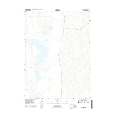
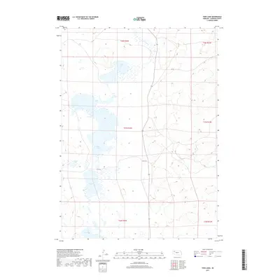
 2021 Twin Lakes2021 Print · USGSSheridan County's Sandhills region is captured here in the early twenty-first century, showing a remote landscape of natural basins. Researchers can trace the water levels and tracks through this terrain, from Cravath Lake down to Diamond Lake and Joy Lake.
End of results
Showing maps 1-11 of 11
Frequently asked questions
- What are the different types of historical maps available for Speer Ranch?
- What is the oldest map of Speer Ranch?
- Where can I purchase historical maps of Speer Ranch for my home or office?
- Where can I download high-res historical maps of Speer Ranch?
- Are there historical topographic maps available for Speer Ranch?
- Is there historical aerial imagery available for Speer Ranch?
- Where are historical maps of Speer Ranch sourced from?