1970s Maps of Thurston County, Nebraska
Explore 4 historic maps of Thurston County from the 1970s. These maps offer a rare glimpse into what life looked like during the 1970s — showing old roads, neighborhoods, homes, and landmarks that have changed or disappeared over time.
Whether you're researching your family's past, planning a metal detecting trip, or studying how Thurston County's landscape evolved across the 1970s, these high-resolution maps are a powerful tool for exploring the history of this region.
- Focus on a specific era: All maps on this page are from the 1970s, giving you a focused view of this time period.
- See what’s changed: Compare century-old streets, trails, and buildings to today's modern landscape using overlays and satellite layers.
- Research with precision: Use these maps for genealogy, historical research, land use analysis, or educational projects.
- View, download, or print: Maps are fully viewable online in high resolution, and can be downloaded or printed for your own records.
Start exploring Thurston County's history through authentic maps from the 1970s. This is your window into the past.
Thurston County, NE maps
(4)- 1977 Map of Salix, 1979 Print
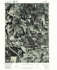 1977 Salix1979 Print · USGSThe Woodbury County floodplain is captured in the late seventies, showing the landscape shaped by the shifting channel of the Missouri River. Researchers can trace the development of Salix and study the intricate network of farm lanes and field patterns.
 - 1977 Map of Walthill, 1979 Print
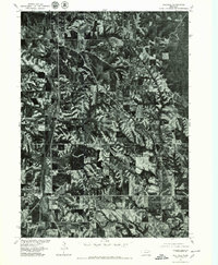 1977 Walthill1979 Print · USGSThurston County’s agricultural and residential landscape is revealed in this late seventies aerial survey of the region between Winnebago and Walthill. Researchers can trace the development of these communities and the meandering course of Omaha Creek as it cuts through the wooded ravines and farmland.
 - 1977 Map of Albaton, 1979 Print
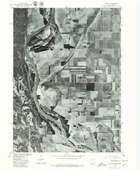 1977 Albaton1979 Print · USGSThe Missouri River floodplain near the Iowa and Nebraska border is captured here during the late 1970s. Local researchers and landowners can trace field patterns and the layout of the rural settlement at Albaton near the Missouri River.
 - 1977 Map of Homer, 1979 Print
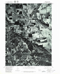 1977 Homer1979 Print · USGSHomer and the Missouri River valley appear in sharp detail during the late seventies through this aerial orthophotograph. Genealogists and local historians can trace the town of Homer and the water management patterns along Omaha Creek and the Missouri River.
End of results
Showing maps 1-4 of 4
Top cities of Thurston County
- Pender historical maps
- Walthill historical maps
- Winnebago historical maps
- Rosalie historical maps
- Thurston historical maps
Frequently asked questions
- What are the different types of historical maps available for Thurston County?
- What is the oldest map of Thurston County?
- Where can I purchase historical maps of Thurston County for my home or office?
- Where can I download high-res historical maps of Thurston County?
- Are there historical topographic maps available for Thurston County?
- Is there historical aerial imagery available for Thurston County?
- Where are historical maps of Thurston County sourced from?