1960s Maps of Macy, Nebraska
Explore 4 historic maps of Macy from the 1960s. These maps offer a rare glimpse into what life looked like during the 1960s — showing old roads, neighborhoods, homes, and landmarks that have changed or disappeared over time.
Whether you're researching your family's past, planning a metal detecting trip, or studying how Macy's landscape evolved across the 1960s, these high-resolution maps are a powerful tool for exploring the history of this region.
- Focus on a specific era: All maps on this page are from the 1960s, giving you a focused view of this time period.
- See what’s changed: Compare century-old streets, trails, and buildings to today's modern landscape using overlays and satellite layers.
- Research with precision: Use these maps for genealogy, historical research, land use analysis, or educational projects.
- View, download, or print: Maps are fully viewable online in high resolution, and can be downloaded or printed for your own records.
Start exploring Macy's history through authentic maps from the 1960s. This is your window into the past.
Macy, NE maps
(4)- 1966 Map of Walthill SW, 1967 Print
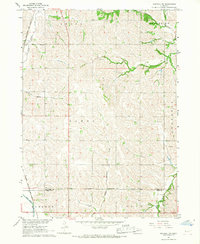 1966 Walthill SW1967 Print · USGSThurston and Burt County landscapes are captured here in the mid-1960s, showing the intersection of tribal lands and rural development. Trace the rail corridor of the Chicago Burlington and Quincy or locate the old Martin Sch.
 - 1966 Map of Walthill, 1968 Print
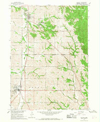 1966 Walthill1968 Print · USGSThurston County, Nebraska, is seen here during the mid-sixties, dominated by the intersecting borders of tribal lands. Researchers can trace the Old Indian Treaty Boundary and locate local landmarks like the St Augustine Indian Mission and Winnebago Cem.
 - 1966 Map of Macy, 1968 Print
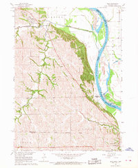 1966 Macy1968 Print · USGSThe Omaha Indian Reservation and the Missouri River bluffs are documented here in the mid-sixties. Genealogists and local historians can trace rural homestead patterns near Macy, the site of Omaha Tribal Cem, and several numbered schools such as School No 14.
 - 1969 Map of Albaton, 1971 Print
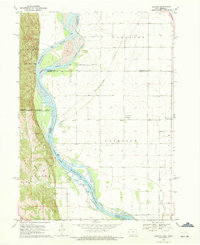 1969 Albaton1971 Print · USGSThe Missouri River valley along the Iowa-Nebraska border comes to life in this late sixties survey of Monona County. Researchers can trace the intricate Winnebago Indian Reservation Boundary and locate local landmarks like Albaton, Fairview Cem, and Sand Hill Lake.
End of results
Showing maps 1-4 of 4
Top cities near Macy
- Sloan historical maps
- Lyons historical maps
- Walthill historical maps
- Winnebago historical maps
- Winnebago historical maps
- Whiting historical maps
See more
Frequently asked questions
- What are the different types of historical maps available for Macy?
- What is the oldest map of Macy?
- Where can I purchase historical maps of Macy for my home or office?
- Where can I download high-res historical maps of Macy?
- Are there historical topographic maps available for Macy?
- Is there historical aerial imagery available for Macy?
- Where are historical maps of Macy sourced from?