
1966 Map of Walthill SW
USGS Topo · Published 1967About this map
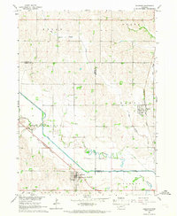
The Omaha Indian Reservation Boundary defines the northern landscape of this mid-1960s Nebraska survey, crossing a terrain of rolling hills and creek valleys. Settled rural activity is centered around the Martin Sch and various local resources, including several Gravel Pits and a Sandpit scattered across the eastern sections. The Chicago Burlington and Quincy railroad cuts through the western edge of the quadrangle, following the course of South Omaha Creek. To the south, the Thurston Co Burt Co line marks the transition between counties. The drainage patterns are significant here, featuring the winding South Blackbird Creek and the engineered path of the Logan Creek Dredge, reflecting the region's historical focus on agricultural land management and water control in the Missouri River Basin.
Find a feature on this map
17 named features on this map. Tap any name to fly to it.
Don’t see what you’re looking for? This feature index may not catch every label — zoom into the map to look around manually.
Map Details
Editions of this 1966 Walthill SW Map
This is the sole edition of this map. No revisions or reprints were ever made.
Other maps of this area

1955 · Sioux City
USGS Topo · 1:250,000

1955 · Fremont
USGS Topo · 1:250,000

1957 · Fremont
USGS Topo · 1:250,000

1958 · Sioux City
USGS Topo · 1:250,000

1958 · Fremont
USGS Topo · 1:250,000

1959 · Sioux City
USGS Topo · 1:250,000

1966 · Lyons
USGS Topo · 1:24,000

1966 · West Point NE
USGS Topo · 1:24,000

1966 · Walthill
USGS Topo · 1:24,000
1966 · Bancroft
USGS Topo · 1:24,000