1900s (20th Century) Maps of North Loup, Nebraska
Explore 6 historic maps of North Loup from the 1900s (20th Century). These maps offer a rare glimpse into what life looked like during the 1900s — showing old roads, neighborhoods, homes, and landmarks that have changed or disappeared over time.
Whether you're researching your family's past, planning a metal detecting trip, or studying how North Loup's landscape evolved across the 1900s, these high-resolution maps are a powerful tool for exploring the history of this region.
- Focus on a specific era: All maps on this page are from the 1900s, giving you a focused view of this time period.
- See what’s changed: Compare century-old streets, trails, and buildings to today's modern landscape using overlays and satellite layers.
- Research with precision: Use these maps for genealogy, historical research, land use analysis, or educational projects.
- View, download, or print: Maps are fully viewable online in high resolution, and can be downloaded or printed for your own records.
Start exploring North Loup's history through authentic maps from the 1900s. This is your window into the past.
North Loup, NE maps
(6)- 1953 Map of North Loup, 1955 Print
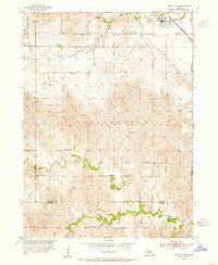 1953 North Loup1955 Print · USGSNorth Loup and its surrounding townships are shown in the early fifties, capturing a period when rural schoolhouses still dotted the Nebraska landscape. Researchers can trace the Union Pacific rail line and find local landmarks like Hillside Cem, Pleasant Hill Sch, and Deer Creek Sch.2 unique versions available
 - 1954 Map of Ord SE, 1955 Print
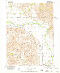 1954 Ord SE1955 Print · USGSValley and Greeley Counties are captured here in the mid-fifties, showing a river valley defined by its irrigation canals and dual railroads. Genealogists and historians can trace the locations of rural schools like Olean Sch and the rail junctions at Spelts and North Loup.3 unique versions available
 - 1955 Map of Broken Bow
 1955 Broken Bow1955 Print · USGSCentral Nebraska in the mid-fifties is defined by the sweeping Sand Hills and the vital river valleys that supported its ranching and rail towns. Researchers can trace the rail corridors of the Union Pacific RR and locate settlements like Dannebrog, Broken Bow, and Brewster.5 unique versions available
 - 1956 Map of Broken Bow
 1956 Broken Bow1956 Print · USGSCentral Nebraska during the mid-fifties reveals a region defined by its river-valley railroads and the rolling Sand Hills. Genealogists and local historians can trace the paths of the Chicago Burlington and Quincy through towns like Broken Bow, Merna, and Anselmo.
 - 1985 Map of St. Paul
 1985 St. Paul1985 Print · USGSCentral Nebraska's river valleys and rail towns are captured here in the mid-eighties, showing the region's agricultural and cultural foundations. Researchers can trace historic communities like Dannebrog, Scotia, and Nysted, or locate landmarks such as Sherman Reservoir and Happy Jack Peak.2 unique versions available
 - 1985 Map of Ord
 1985 Ord1985 Print · USGSCentral Nebraska's river valleys were defined by the rail and irrigation networks of the mid-1980s. Genealogists can trace family roots in towns like Ord and Albion or locate landmarks like Pilot Knob and the Pibel Lake State Recreation Area.2 unique versions available
End of results
Showing maps 1-6 of 6
Top cities near North Loup
- Ord historical maps
- Loup City historical maps
- Scotia historical maps
- Elba historical maps
- Cotesfield historical maps
Frequently asked questions
- What are the different types of historical maps available for North Loup?
- What is the oldest map of North Loup?
- Where can I purchase historical maps of North Loup for my home or office?
- Where can I download high-res historical maps of North Loup?
- Are there historical topographic maps available for North Loup?
- Is there historical aerial imagery available for North Loup?
- Where are historical maps of North Loup sourced from?