
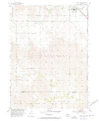
1953 Map of North Loup
USGS Topo · Published 1955About this map
North Loup serves as the primary hub of this 1950s agricultural landscape, situated along the Union Pacific railroad and the North Loup Canal. The map reveals a highly organized rural education system, with numerous localized schoolhouses such as School No 46, School No 8, and Pleasant Hill Sch distributed to serve the farming families across North Loup and Independent townships. This density of schools indicates a vibrant, well-populated countryside at the time of the survey.
Find a feature on this map
20 named features on this map. Tap any name to fly to it.
Don’t see what you’re looking for? This feature index may not catch every label — zoom into the map to look around manually.
Map Details
Editions of this 1953 North Loup Map
2 editions found
Other maps of this area

1899 · Loup
USGS Topo · 1:125,000

1953 · Loup City NW
USGS Topo · 1:24,000

1953 · Cotesfield
USGS Topo · 1:24,000

1953 · Scotia
USGS Topo · 1:24,000

1953 · Loup City SE
USGS Topo · 1:24,000

1953 · Loup City
USGS Topo · 1:24,000

1954 · Ord SE
USGS Topo · 1:24,000

1954 · Ord
USGS Topo · 1:24,000

1954 · Horace
USGS Topo · 1:24,000

1955 · Broken Bow
USGS Topo · 1:250,000