
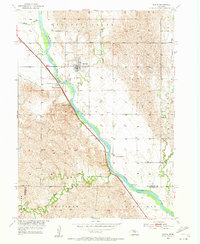
1953 Map of Scotia
USGS Topo · Published 1955About this map
The village of Scotia serves as the central hub of this mid-century survey, situated where the Union Pacific railroad tracks and the North Loup River valley converge. This era reveals a landscape shaped by both natural watercourses and human engineering, featuring the North Loup Canal and a Gaging Station monitoring the river's flow. Local industry and geography meet at Happy Jack Peak, which was also the site of the Happy Jack Peak Mine south of town.
Find a feature on this map
20 named features on this map. Tap any name to fly to it.
Don’t see what you’re looking for? This feature index may not catch every label — zoom into the map to look around manually.
Map Details
Editions of this 1953 Scotia Map
2 editions found
Other maps of this area

1899 · Loup
USGS Topo · 1:125,000

1953 · Cotesfield
USGS Topo · 1:24,000

1953 · North Loup
USGS Topo · 1:24,000

1953 · Scotia NE
USGS Topo · 1:24,000

1953 · Loup City SE
USGS Topo · 1:24,000

1953 · Elba
USGS Topo · 1:24,000

1954 · Ord SE
USGS Topo · 1:24,000

1954 · Horace
USGS Topo · 1:24,000

1954 · Greeley
USGS Topo · 1:24,000

1955 · Broken Bow
USGS Topo · 1:250,000