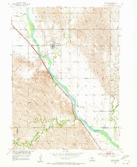
1953 Map of Scotia
USGS Topo · Published 1955About this map
The village of Scotia serves as the central hub of this 1953 survey, situated along the North Loup River in central Nebraska. This mid-century study, conducted as part of the Department of the Interior's Missouri River Basin project, illustrates a landscape defined by the intersection of water and rail. The Union Pacific railroad tracks parallel the river's course, passing through Scotia Junction and past a Gaging Station south of town. Notable local landmarks include Happy Jack Peak and Mt Hope Cem, which provide specific points of interest for genealogists and local historians.
Find a feature on this map
18 named features on this map. Tap any name to fly to it.
Don’t see what you’re looking for? This feature index may not catch every label — zoom into the map to look around manually.
Map Details
Editions of this 1953 Scotia Map
2 editions found
Other maps of this area

1899 · Loup
USGS Topo · 1:125,000

1953 · Cotesfield
USGS Topo · 1:24,000

1953 · North Loup
USGS Topo · 1:24,000

1953 · Scotia NE
USGS Topo · 1:24,000

1953 · Scotia
USGS Topo · 1:24,000

1953 · Loup City SE
USGS Topo · 1:24,000

1953 · Elba
USGS Topo · 1:24,000

1954 · Ord SE
USGS Topo · 1:24,000

1954 · Horace
USGS Topo · 1:24,000

1954 · Greeley
USGS Topo · 1:24,000