
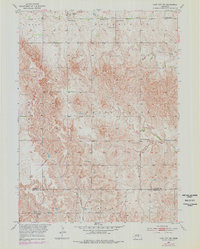
1953 Map of Loup City NW
USGS Topo · Published 1955About this map
The agrarian landscape of central Nebraska is captured here in the early 1950s, showing a meticulously organized network of rural education and community landmarks. The map area is defined by the Valley Co Sherman Co boundary and the drainage patterns of several vital waterways, including Mira Creek and its South Branch. The density of rural schoolhouses, such as School No 15 and School No 67, suggests a vibrant farming population prior to the major school consolidations of the later 20th century. Cultural hubs like the Evangelical Ch and the Davis Creek Cem provide essential anchor points for genealogists researching family ties in this transition zone between Vinton, Enterprise, and Logan. The intricate contouring reflects the undulating prairie terrain that shaped the early settlement and road development of this portion of the Missouri River Basin.
Find a feature on this map
17 named features on this map. Tap any name to fly to it.
Don’t see what you’re looking for? This feature index may not catch every label — zoom into the map to look around manually.
Map Details
Editions of this 1953 Loup City NW Map
2 editions found
Other maps of this area

1899 · Loup
USGS Topo · 1:125,000

1951 · Arcadia SE
USGS Topo · 1:24,000

1951 · Arcadia East
USGS Topo · 1:24,000

1952 · Comstock SE
USGS Topo · 1:24,000

1953 · North Loup
USGS Topo · 1:24,000

1953 · Loup City SE
USGS Topo · 1:24,000

1953 · Loup City
USGS Topo · 1:24,000

1954 · Ord SE
USGS Topo · 1:24,000

1954 · Ord
USGS Topo · 1:24,000

1955 · Broken Bow
USGS Topo · 1:250,000