Old Maps of Carson City, Nevada
Explore 88 old maps of Carson City, spanning from 1891 to today. These high-resolution historic maps reveal how streets, neighborhoods, landmarks, and natural features evolved over time — perfect for genealogy, metal detecting, research, and local history exploration.
What you can do with these maps:
- See how Carson City changed over time: Compare historical maps to modern-day views to trace roads, homesites, rail lines & more.
- View detailed metadata: Each map includes creators, publishers, year, scale, and archive source.
- Overlay maps with satellite & LiDAR: Visualize the past alongside modern tools to explore terrain & human change.
- Trusted historical sources: Maps sourced from the USGS, Library of Congress, and other archives.
- Access maps your way: View online, download high-res files, or order prints for personal or research use.
Start exploring old maps of Carson City to uncover forgotten places, hidden landmarks, and the deep history beneath your feet.
Carson City, NV maps
(88)- 1891 Map of Carson
 1891 Carson1891 Print · USGSSilver mining and rail expansion dominate this late-century look at the Comstock Lode region, from the heights of Virginia to the capital at Carson. Researchers can trace the winding Virginia and Truckee Railroad and locate early sites like Gold Hill, Sutro, and the State Prison.
 - 1891 Map of Truckee
 1891 Truckee1891 Print · USGSThe High Sierra and Lake Tahoe shoreline are captured here in the late nineteenth century as the railroad transformed the mountain economy. Trace the original path of the Central Pacific Railroad through Donner Pass or locate early lakeside landings at Tahoe City and McKinney.
 - 1893 Map of Carson
 1893 Carson1893 Print · USGSThe Comstock Lode era is in full view here during the 1890s, centering on the silver mining centers and early rail networks of the Nevada territory. Trace the path of the Virginia and Truckee R.R. and locate historic sites like Sutro, Gold Hill, and the State Prison near Carson.9 unique versions available
 - 1893 Map of Truckee
 1893 Truckee1893 Print · USGSHigh Sierra transit and industry dominate this late nineteenth-century landscape as the Central Pacific Railroad crosses the divide. Trace the early footprints of Tahoe City, the remote lodges at Rubicon Springs, and the timber operations around Boca.
 - 1895 Map of Truckee
 1895 Truckee1895 Print · USGSThe high Sierra and Lake Tahoe's western shore are captured in the late 1800s as the railroad fueled new mountain industry. Trace the historic Central Pacific route past Boca or locate early lakeside spots like McKinney and Rubicon Springs.9 unique versions available
 - 1932 Map of Truckee
 1932 Truckee1932 Print · USGSThe high Sierra and Lake Tahoe's western shore are captured here in the early thirties as the region balanced industrial mining and timber with a growing seasonal economy. Trace early lakeside developments from Tahoe Tavern to Meeks Bay PO, or locate historical sites like the Walker Mine and Donner Monument.
 - 1940 Map of Truckee
 1940 Truckee1940 Print · USGSThe High Sierra and Lake Tahoe shoreline appear here in the pre-war era, showing a landscape defined by timber, tourism, and transit. Genealogists and historians can trace the early resort development at Tahoe Vista, the lumber works at Hobart Mills, and the vital Southern Pacific rail line.4 unique versions available
 - 1950 Map of Virginia City, 1955 Print
 1950 Virginia City1955 Print · USGSVirginia City and the Comstock mining corridor are seen here at mid-century, amidst a dense concentration of historic shafts and early settlement sites. Researchers can trace the legacy of silver mining through Gold Hill, the Utah Shaft, and several cemeteries that overlook the mountain ranges.3 unique versions available
 - 1952 Map of Virginia City
 1952 Virginia City1952 Print · USGSStorey County's mining heartland is revealed in the mid-century, documenting the legendary Comstock Lode settlements and engineering works. Researchers can trace the massive Sutro Tunnel, locate the Lousetown (Site), and find family roots in Gold Hill or Virginia City.2 unique versions available
 - 1955 Map of Meeks Bay, 1956 Print
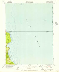 1955 Meeks Bay1956 Print · USGSThe western shores of Lake Tahoe are captured here in the mid-fifties, showing the early footprints of lakeside communities and parklands. Trace the development of Tahoma, Meeks Bay, and Paradise Flat along the edge of the Eldorado National Forest.3 unique versions available
 - 1955 Map of Kings Beach, 1956 Print
 1955 Kings Beach1956 Print · USGSThe north shore of Lake Tahoe is captured during the mid-fifties, showing the growth of resort communities along the California-Nevada line. Trace early lakeside developments from Brockway to Carnelian Bay, or locate local landmarks like the Fish Hatchery and Brockway Golf Club.4 unique versions available
 - 1955 Map of Marlette Lake, 1957 Print
 1955 Marlette Lake1957 Print · USGSThe eastern Nevada shoreline of Lake Tahoe in the mid-1950s reveals a landscape of high-altitude water engineering and steep mountain peaks. Researchers can trace the Virginia City Water Supply Flume and find landmarks like the Incline Guard Sta and Marlette Lake.4 unique versions available
 - 1955 Map of Glenbrook, 1957 Print
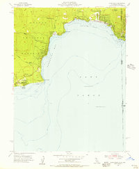
 1955 Glenbrook1957 Print · USGSThe eastern shores of Lake Tahoe come alive in the mid-fifties, showing the developing communities of Glenbrook and Zephyr Cove. Researchers can trace old mountain routes like Genoa Peak Road or locate local landmarks including Tahoe School and Spooner Lake.4 unique versions available
 - 1955 Map of Tahoe, 1958 Print
 1955 Tahoe1958 Print · USGSThe northwest shore of Lake Tahoe in the mid-fifties reveals a developing landscape of lakeside lodges and mountain retreats. Genealogists and historians can trace old community footprints from Tahoe City to Meeks Bay, or locate landmarks like Chambers Lodge and the Ngorchester Mine.3 unique versions available
 - 1956 Map of Dayton, 1958 Print
 1956 Dayton1958 Print · USGSThe silver-country landscape around the Carson River is shown here in the mid-1950s, bridging the mining era and modern institutional development. Researchers can trace the Old RR Grade and locate historic sites such as Mound House and the Daney Mine.3 unique versions available
 - 1956 Map of Carson City, 1958 Print
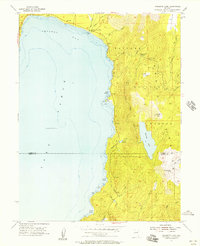
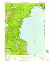
 1956 Carson City1958 Print · USGSIn the mid-fifties, the Nevada state capital and the eastern shores of Lake Tahoe remained distinct, separated by the Carson Range. You can trace institutional history at Stewart and the State Capitol, or locate old burials at Jacks Valley Cemetery.4 unique versions available
 - 1957 Map of Reno, 1963 Print
 1957 Reno1963 Print · USGSWestern Nevada in the early sixties is a land of sprawling desert sinks and rising mountain ranges. Genealogists and historians can trace the rail-and-river network connecting Reno, the mining legacy of Rawhide Mine, and the boundaries of the Pyramid Lake Indian Reservation.5 unique versions available
 - 1958 Map of Chico, 1962 Print
 1958 Chico1962 Print · USGSMid-century Northern California comes to life across the Central Valley and high Sierras as the postwar economy transformed the landscape. Trace the rail lines of the Southern Pacific RR, locate family roots near Chico Cem, or explore the early layout of Paradise and Beale Air Force Base.4 unique versions available
 - 1959 Map of Reno
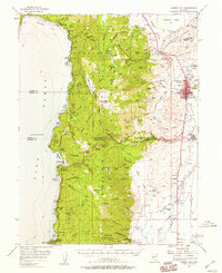
 1959 Reno1959 Print · USGSWestern Nevada in the late fifties was a land of expanding military airbases and high-desert irrigation projects. You can trace the lineage of the Comstock era through Carson City, locate the Pony Express Monument, or study the rail networks of the Southern Pacific RR.
 - 1960 Map of Reno
 1960 Reno1960 Print · USGSThe high desert of western Nevada comes alive in this mid-century survey of the Reno-Tahoe region. Genealogists and historians can trace rail lines like the Southern Pacific RR and locate remote outposts such as Olinghouse, Nixon, and the Olinghouse Mine.2 unique versions available
 - 1960 Map of Chico
 1960 Chico1960 Print · USGSThe Northern California high country and Sacramento Valley meet in this 1960s-era landscape of mining towns and river settlements. Trace the rail-and-water economy of the gold country through the Empire Mine, Beale Air Force Base, and the Western Pacific Railroad.
 - 1960 Map of Virginia City, 1976 Print
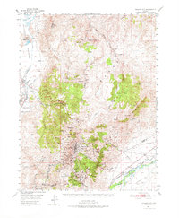 1960 Virginia City1976 Print · USGSThe Comstock Lode is shown in detail at mid-century, mapping the industrial footprint of the silver mining boom. Genealogists and historians can locate mining infrastructure, the Sutro Tunnel, and settlements like Gold Hill, Silver City, and American Flat.
 - 1967 Map of Virginia City, 1971 Print
 1967 Virginia City1971 Print · USGSVirginia City and the Comstock Lode mining district are shown here in the late sixties, highlighting the intense industrial footprint of the Nevada silver boom. Local historians can trace the foundations of Gold Hill, the Sutro Tunnel, and family sites near the Hebrew Cem.3 unique versions available
 - 1968 Map of New Empire, 1971 Print
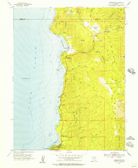
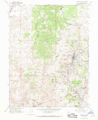
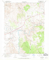 1968 New Empire1971 Print · USGSCarson City and the Virginia Range meet in this late-sixties study of Nevada's industrial heartland and growing capital. Researchers can trace the ruins of historic silver-processing sites like the Morgan Mill and the Old Mexican Mill along the Carson River.3 unique versions available
 - 1968 Map of McTarnahan Hill, 1971 Print
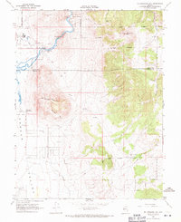 1968 McTarnahan Hill1971 Print · USGSThe Carson River corridor south of the state capital is captured here in the late sixties as industrial sites and institutional lands expanded. Researchers can trace land allotments, the Nevada State Medium Security Prison, and historic sites like Saratoga Hot Spring.4 unique versions available
Showing maps 1-25 of 88
Top cities of Carson City
Frequently asked questions
- What are the different types of historical maps available for Carson City?
- What is the oldest map of Carson City?
- Where can I purchase historical maps of Carson City for my home or office?
- Where can I download high-res historical maps of Carson City?
- Are there historical topographic maps available for Carson City?
- Is there historical aerial imagery available for Carson City?
- Where are historical maps of Carson City sourced from?