1970s Maps of Carson City, Nevada
Explore 5 historic maps of Carson City from the 1970s. These maps offer a rare glimpse into what life looked like during the 1970s — showing old roads, neighborhoods, homes, and landmarks that have changed or disappeared over time.
Whether you're researching your family's past, planning a metal detecting trip, or studying how Carson City's landscape evolved across the 1970s, these high-resolution maps are a powerful tool for exploring the history of this region.
- Focus on a specific era: All maps on this page are from the 1970s, giving you a focused view of this time period.
- See what’s changed: Compare century-old streets, trails, and buildings to today's modern landscape using overlays and satellite layers.
- Research with precision: Use these maps for genealogy, historical research, land use analysis, or educational projects.
- View, download, or print: Maps are fully viewable online in high resolution, and can be downloaded or printed for your own records.
Start exploring Carson City's history through authentic maps from the 1970s. This is your window into the past.
Carson City, NV maps
(5)- 1974 Map of Virginia City, 1977 Print
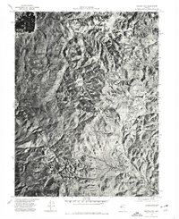 1974 Virginia City1977 Print · USGSVirginia City and the Comstock region are seen from above in the mid-1970s, revealing the dense settlement patterns and the mining-scarred landscape. Trace historic drainages like Gold Canyon or examine the rugged layout of the Virginia Range.
 - 1974 Map of New Empire, 1977 Print
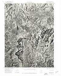 1974 New Empire1977 Print · USGSCarson City and the adjacent industrial site of New Empire are shown in detail through mid-1970s aerial photography. Trace the city’s expansion into Eagle Valley and follow the natural curves of the Carson River as it winds toward the foothills.
 - 1974 Map of Carson City, 1977 Print
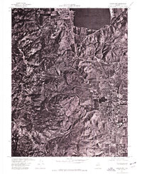 1974 Carson City1977 Print · USGSCarson City and the surrounding Nevada high desert are captured in this mid-seventies aerial study. Researchers can trace the mid-century footprint of Carson City within Eagle Valley and the shoreline of Washoe Lake.
 - 1977 Map of Truckee, 1978 Print
 1977 Truckee1978 Print · USGSThe High Sierra and Lake Tahoe regions come into focus in the late seventies, showing a landscape defined by massive reservoir projects and mountain transit. Genealogists and historians can trace the Southern Pacific rail line through Truckee or explore old mining districts near North Bloomfield and Colfax.2 unique versions available
 - 1979 Map of Carson City, 1980 Print
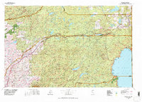
 1979 Carson City1980 Print · USGSWestern Nevada in the late seventies reveals a landscape of historic mining districts and expanding mountain communities. Researchers can trace the Comstock Lode through Virginia City, locate the Stewart Indian School, or explore the shores of Lake Tahoe near Incline Village.2 unique versions available
End of results
Showing maps 1-5 of 5
Top cities of Carson City
Frequently asked questions
- What are the different types of historical maps available for Carson City?
- What is the oldest map of Carson City?
- Where can I purchase historical maps of Carson City for my home or office?
- Where can I download high-res historical maps of Carson City?
- Are there historical topographic maps available for Carson City?
- Is there historical aerial imagery available for Carson City?
- Where are historical maps of Carson City sourced from?