1990s Maps of Carson City, Nevada
Explore 10 historic maps of Carson City from the 1990s. These maps offer a rare glimpse into what life looked like during the 1990s — showing old roads, neighborhoods, homes, and landmarks that have changed or disappeared over time.
Whether you're researching your family's past, planning a metal detecting trip, or studying how Carson City's landscape evolved across the 1990s, these high-resolution maps are a powerful tool for exploring the history of this region.
- Focus on a specific era: All maps on this page are from the 1990s, giving you a focused view of this time period.
- See what’s changed: Compare century-old streets, trails, and buildings to today's modern landscape using overlays and satellite layers.
- Research with precision: Use these maps for genealogy, historical research, land use analysis, or educational projects.
- View, download, or print: Maps are fully viewable online in high resolution, and can be downloaded or printed for your own records.
Start exploring Carson City's history through authentic maps from the 1990s. This is your window into the past.
Carson City, NV maps
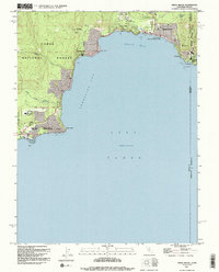
(10)- 1992 Map of Meeks Bay, 1994 Print
 1992 Meeks Bay1994 Print · USGSThe West Shore of Lake Tahoe in the early nineties reveals a landscape of lakeside communities and protected state parklands. Researchers can trace the development of Tahoma, locate the historic Ehrman Mansion, and identify recreation sites like Meeks Bay Campground.
 - 1992 Map of Kings Beach, 1994 Print
 1992 Kings Beach1994 Print · USGSThe North Shore of Lake Tahoe comes into focus in the early nineties, showing the established communities of Kings Beach and Carnelian Bay. Trace the local development and landmarks like the Fish Hatchery, Brockway Spring, and Dollar Reservoir.2 unique versions available
 - 1992 Map of Marlette Lake, 1994 Print
 1992 Marlette Lake1994 Print · USGSThe northeastern shore of Lake Tahoe comes into focus during the early nineties, showcasing the expansion of alpine communities and parks. Researchers can trace local development through Incline Village, the Ponderosa Ranch, and the protected waters of Marlette Lake.2 unique versions available
 - 1992 Map of Glenbrook, 1994 Print
 1992 Glenbrook1994 Print · USGSThe eastern shore of Lake Tahoe in the early nineties shows a landscape of growing mountain communities and protected forest land. Local historians can trace the development of Lincoln Park and Skyland or locate landmarks like Cave Rock and the Spooner Guard Station.2 unique versions available
 - 1993 Map of Dayton
 1993 Dayton1993 Print · USGSDayton and the surrounding Comstock foothills appear in the early nineties as a landscape defined by its mining heritage and river valley life. Researchers can trace the town's layout near Dayton State Park and locate numerous hillside prospects, a Mine Shaft, and the old Cem.
 - 1994 Map of Carson City
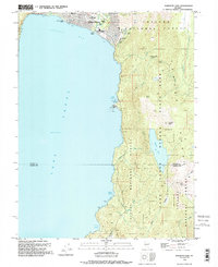
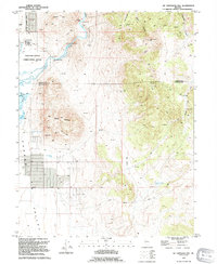
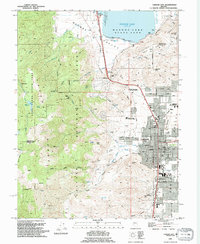 1994 Carson City1994 Print · USGSThe Nevada capital and the eastern slopes of the Carson Range are captured here in the mid-nineties. Researchers can trace historic transit lines like the Virginia & Truckee RR or locate landmarks such as the Lone Mtn Cemetery and Carson Hot Springs.2 unique versions available
 - 1994 Map of New Empire
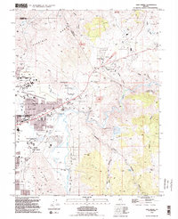 1994 New Empire1994 Print · USGSEastern Carson City and the rugged foothills of the Virginia Range are captured in the mid-1990s as the state capital expanded toward its historic mining districts. Researchers can find landmarks like the Nevada State Prison and the Old Mexican Mill, along with the site of Mound House.2 unique versions available
 - 1994 Map of Genoa
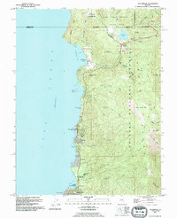
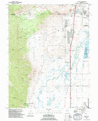 1994 Genoa1994 Print · USGSGenoa and the surrounding Carson Valley are captured in the mid-1990s, showcasing the intersection of pioneer history and modern Nevada infrastructure. Researchers can trace early settlements at the Morman Station Historic State Mon or locate the Jacks Valley Cem and Hobo Hot Springs.
 - 1994 Map of Virginia City
 1994 Virginia City1994 Print · USGSThe Comstock Lode district is preserved in this late-century survey, detailing the mining heart of Nevada. Genealogists and historians can trace the foundations of Virginia City through landmarks like the 4th Ward Sch Museum and numerous historic plots including the Masonic Cem.2 unique versions available
 - 1994 Map of McTarnahan Hill
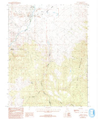
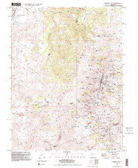
 1994 McTarnahan Hill1994 Print · USGSThe Nevada high desert at the edge of the Carson Valley comes to life in this mid-1990s survey. Genealogists and local historians can trace the developments around the Northern Nevada Correctional Center or locate the historic McTarnahan Bridge (Site) and Bunker Hill Mine.
End of results
Showing maps 1-10 of 10
Top cities of Carson City
Frequently asked questions
- What are the different types of historical maps available for Carson City?
- What is the oldest map of Carson City?
- Where can I purchase historical maps of Carson City for my home or office?
- Where can I download high-res historical maps of Carson City?
- Are there historical topographic maps available for Carson City?
- Is there historical aerial imagery available for Carson City?
- Where are historical maps of Carson City sourced from?