1980s Maps of Carson City, Nevada
Explore 2 historic maps of Carson City from the 1980s. These maps offer a rare glimpse into what life looked like during the 1980s — showing old roads, neighborhoods, homes, and landmarks that have changed or disappeared over time.
Whether you're researching your family's past, planning a metal detecting trip, or studying how Carson City's landscape evolved across the 1980s, these high-resolution maps are a powerful tool for exploring the history of this region.
- Focus on a specific era: All maps on this page are from the 1980s, giving you a focused view of this time period.
- See what’s changed: Compare century-old streets, trails, and buildings to today's modern landscape using overlays and satellite layers.
- Research with precision: Use these maps for genealogy, historical research, land use analysis, or educational projects.
- View, download, or print: Maps are fully viewable online in high resolution, and can be downloaded or printed for your own records.
Start exploring Carson City's history through authentic maps from the 1980s. This is your window into the past.
Carson City, NV maps
(2)- 1987 Map of Dayton, 1988 Print
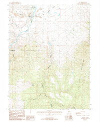 1987 Dayton1988 Print · USGSDayton and the surrounding Carson River valley were centers of intense mineral exploration and desert irrigation in the late eighties. Researchers can trace the legacy of mining through the Dixon Mine, explore the Gold Canyon district, or locate the local Cem.
 - 1987 Map of Mineral Peak, 1988 Print
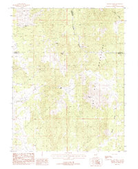 1987 Mineral Peak1988 Print · USGSThe Pine Nut Mountains and the high-desert borderlands of Carson City and Douglas County are captured here in the late eighties. Researchers can locate numerous mining prospects and historical workings such as the Jane Ellen Mine and the Utopian Mine.3 unique versions available
End of results
Showing maps 1-2 of 2
Top cities of Carson City
Frequently asked questions
- What are the different types of historical maps available for Carson City?
- What is the oldest map of Carson City?
- Where can I purchase historical maps of Carson City for my home or office?
- Where can I download high-res historical maps of Carson City?
- Are there historical topographic maps available for Carson City?
- Is there historical aerial imagery available for Carson City?
- Where are historical maps of Carson City sourced from?