1970s Maps of Boulder City, Nevada
Explore 4 historic maps of Boulder City from the 1970s. These maps offer a rare glimpse into what life looked like during the 1970s — showing old roads, neighborhoods, homes, and landmarks that have changed or disappeared over time.
Whether you're researching your family's past, planning a metal detecting trip, or studying how Boulder City's landscape evolved across the 1970s, these high-resolution maps are a powerful tool for exploring the history of this region.
- Focus on a specific era: All maps on this page are from the 1970s, giving you a focused view of this time period.
- See what’s changed: Compare century-old streets, trails, and buildings to today's modern landscape using overlays and satellite layers.
- Research with precision: Use these maps for genealogy, historical research, land use analysis, or educational projects.
- View, download, or print: Maps are fully viewable online in high resolution, and can be downloaded or printed for your own records.
Start exploring Boulder City's history through authentic maps from the 1970s. This is your window into the past.
Boulder City, NV maps
(4)- 1970 Map of Henderson, 1972 Print
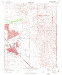 1970 Henderson1972 Print · USGSHenderson and the southeastern Las Vegas Valley appear here at the start of the 1970s, showcasing a growing desert city. Researchers can trace local neighborhoods like Carver Park, industrial landmarks such as the Three Kids Mine, and the route of the Union Pacific railroad.4 unique versions available
 - 1970 Map of Boulder Beach, 1973 Print
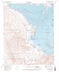 1970 Boulder Beach1973 Print · USGSLake Mead in the early seventies shows a landscape defined by critical water infrastructure and desert recreation. Trace the Old Railroad Grade past the Lake Mead Lodge or locate early facilities like the Hemenway Campground.2 unique versions available
 - 1973 Map of Henderson, 1977 Print
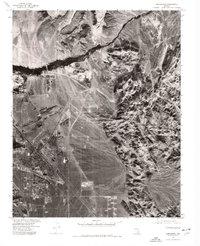 1973 Henderson1977 Print · USGSSouthern Nevada during the early seventies is captured here as the desert landscape around Henderson began to undergo rapid transformation. Trace the development of residential grids alongside the Union Pacific tracks and the natural drainage of the Las Vegas Wash.
 - 1973 Map of Boulder Beach, 1977 Print
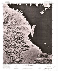 1973 Boulder Beach1977 Print · USGSThe Clark County shoreline and the vast waters of the reservoir appear in high-altitude detail in the early 1970s. Researchers can trace early recreational development and terrain patterns at Boulder Harbor, Boulder Beach, and Las Vegas Bay.
End of results
Showing maps 1-4 of 4
Top cities near Boulder City
Frequently asked questions
- What are the different types of historical maps available for Boulder City?
- What is the oldest map of Boulder City?
- Where can I purchase historical maps of Boulder City for my home or office?
- Where can I download high-res historical maps of Boulder City?
- Are there historical topographic maps available for Boulder City?
- Is there historical aerial imagery available for Boulder City?
- Where are historical maps of Boulder City sourced from?