1950s Maps of Boulder City, Nevada
Explore 13 historic maps of Boulder City from the 1950s. These maps offer a rare glimpse into what life looked like during the 1950s — showing old roads, neighborhoods, homes, and landmarks that have changed or disappeared over time.
Whether you're researching your family's past, planning a metal detecting trip, or studying how Boulder City's landscape evolved across the 1950s, these high-resolution maps are a powerful tool for exploring the history of this region.
- Focus on a specific era: All maps on this page are from the 1950s, giving you a focused view of this time period.
- See what’s changed: Compare century-old streets, trails, and buildings to today's modern landscape using overlays and satellite layers.
- Research with precision: Use these maps for genealogy, historical research, land use analysis, or educational projects.
- View, download, or print: Maps are fully viewable online in high resolution, and can be downloaded or printed for your own records.
Start exploring Boulder City's history through authentic maps from the 1950s. This is your window into the past.
Boulder City, NV maps
(13)- 1952 Map of Henderson, 1956 Print
 1952 Henderson1956 Print · USGSHenderson and the shores of Lake Mead are shown here in the early fifties during an era of significant industrial expansion. Researchers can trace the layout of worker housing at Victory Village and Carver Park or locate the sprawling Magnesium Plant and Three Kids Mine.2 unique versions available
 - 1954 Map of Las Vegas
 1954 Las Vegas1954 Print · USGSLas Vegas and the Mojave Desert are shown in the early fifties as the region's military and recreational footprint expanded. Genealogists and historians can trace the early layout of North Las Vegas, the sites of Indian Springs Air Force Base, and long-established towns like Bunkerville.5 unique versions available
 - 1954 Map of Kingman, 1964 Print
 1954 Kingman1964 Print · USGSThe High Desert borderlands come to life in the mid-fifties, showing the intersection of mining legacies and massive river projects. Researchers can trace old rail stops like Roach Station, mining sites such as Chloride, and river landmarks like Searchlight Ferry.4 unique versions available
 - 1955 Map of Kingman
 1955 Kingman1955 Print · USGSThe Mojave Desert and Colorado River corridor come alive in the mid-fifties, showing a landscape of mining camps and rail junctions. Trace the river to the Searchlight Ferry or locate old desert mining sites like Goldroad and the Great Monster Mine.
 - 1957 Map of Las Vegas
 1957 Las Vegas1957 Print · USGSSouthern Nevada in the mid-fifties is a landscape of massive federal ranges and the early growth of Las Vegas. Researchers can trace the development of McCarran Field, the expansive Lake Mead National Recreation Area, and the industrial footprint of Henderson.
 - 1958 Map of Kingman
 1958 Kingman1958 Print · USGSThe tri-state desert borders of Arizona, Nevada, and California are shown in the late fifties as a network of mining camps and river crossings. Genealogists and historians can trace the legacy of remote outposts like Oatman, Chloride, and the Searchlight Ferry along the Colorado River.2 unique versions available
 - 1958 Map of Boulder City SW, 1959 Print
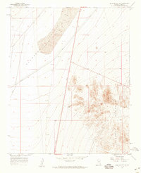 1958 Boulder City SW1959 Print · USGSThe Clark County desert is captured here in the late fifties, showcasing the transition from open basins to mountain ranges. Historians can trace early infrastructure along 95 and locate mining remnants like several Shafts tucked into the Eldorado Mountains.2 unique versions available
 - 1958 Map of Nelson, 1959 Print
 1958 Nelson1959 Print · USGSThe Eldorado Canyon mining district is captured here in the late fifties, during a period of active high-desert exploration. Genealogists and historians can locate dozens of individual claims and camps, including the Techatticup Mine, Capital Camp, and the Occidental Mine.2 unique versions available
 - 1958 Map of Boulder City SE, 1959 Print
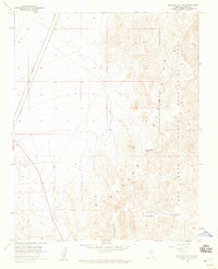 1958 Boulder City SE1959 Print · USGSNevada's desert landscape south of Boulder City is documented here during the late fifties, showing the edge of the Lake Mead National Recreation Area. Researchers can locate isolated landmarks like Forlorn Hope Spring and the winding path of Lonesome Wash.2 unique versions available
 - 1958 Map of Boulder City NW, 1959 Print
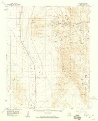
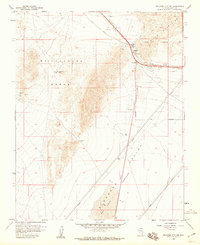 1958 Boulder City NW1959 Print · USGSThe Clark County desert in the late fifties was a hub of mining and rail transit between the mountain ranges. Geologists and historians can trace the Union Pacific line through Railroad Pass and locate mineral claims like the Quo Vadis Mine or the Alunite Mine.4 unique versions available
 - 1958 Map of Boulder City, 1959 Print
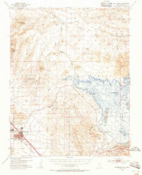
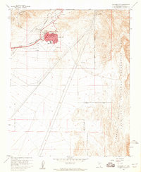 1958 Boulder City1959 Print · USGSBoulder City was a specialized hub of government rail and aviation in the late fifties. You can trace the path of the U S Government RR and find mid-century landmarks like the Boulder City Airport and the Filtration Plant.3 unique versions available
 - 1958 Map of Boulder City, 1961 Print
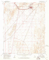 1958 Boulder City1961 Print · USGSBoulder City and the surrounding desert peaks were a hub of mining and federal planning in the late fifties. Genealogists and historians can trace the early rail corridor through Railroad Pass, find old mining sites like the Alunite Mine, and locate remote desert water sources like Forlorn Hope Spr.2 unique versions available
 - 1959 Map of Las Vegas
 1959 Las Vegas1959 Print · USGSSouthern Nevada in the late fifties was a landscape of rapid suburban growth and massive federal installations. Genealogists and historians can trace early housing at Victory Village, the grounds of Camp Desert Rock, and the remote Tule Springs Ranch.
End of results
Showing maps 1-13 of 13
Top cities near Boulder City
Frequently asked questions
- What are the different types of historical maps available for Boulder City?
- What is the oldest map of Boulder City?
- Where can I purchase historical maps of Boulder City for my home or office?
- Where can I download high-res historical maps of Boulder City?
- Are there historical topographic maps available for Boulder City?
- Is there historical aerial imagery available for Boulder City?
- Where are historical maps of Boulder City sourced from?