1900s (20th Century) Maps of Tuscany Residential Village, Henderson
Explore 9 historic maps of Tuscany Residential Village from the 1900s (20th Century). These maps offer a rare glimpse into what life looked like during the 1900s — showing old roads, neighborhoods, homes, and landmarks that have changed or disappeared over time.
Whether you're researching your family's past, planning a metal detecting trip, or studying how Tuscany Residential Village's landscape evolved across the 1900s, these high-resolution maps are a powerful tool for exploring the history of this region.
- Focus on a specific era: All maps on this page are from the 1900s, giving you a focused view of this time period.
- See what’s changed: Compare century-old streets, trails, and buildings to today's modern landscape using overlays and satellite layers.
- Research with precision: Use these maps for genealogy, historical research, land use analysis, or educational projects.
- View, download, or print: Maps are fully viewable online in high resolution, and can be downloaded or printed for your own records.
Start exploring Tuscany Residential Village's history through authentic maps from the 1900s. This is your window into the past.
Tuscany Residential Village, Henderson maps
(9)- 1926 Map of Boulder Canyon
 1926 Boulder Canyon1926 Print · USGSBefore the completion of the Hoover Dam, this 1920s survey documents the Colorado River basin and its burgeoning infrastructure. Researchers can trace early railroad stops at Apex and Garnet, or locate the original Boulder Canyon Dam Site and Bonelli landing.2 unique versions available
 - 1952 Map of Henderson, 1956 Print
 1952 Henderson1956 Print · USGSHenderson and the shores of Lake Mead are shown here in the early fifties during an era of significant industrial expansion. Researchers can trace the layout of worker housing at Victory Village and Carver Park or locate the sprawling Magnesium Plant and Three Kids Mine.2 unique versions available
 - 1954 Map of Las Vegas
 1954 Las Vegas1954 Print · USGSLas Vegas and the Mojave Desert are shown in the early fifties as the region's military and recreational footprint expanded. Genealogists and historians can trace the early layout of North Las Vegas, the sites of Indian Springs Air Force Base, and long-established towns like Bunkerville.5 unique versions available
 - 1957 Map of Las Vegas
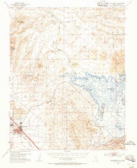
 1957 Las Vegas1957 Print · USGSSouthern Nevada in the mid-fifties is a landscape of massive federal ranges and the early growth of Las Vegas. Researchers can trace the development of McCarran Field, the expansive Lake Mead National Recreation Area, and the industrial footprint of Henderson.
 - 1959 Map of Las Vegas
 1959 Las Vegas1959 Print · USGSSouthern Nevada in the late fifties was a landscape of rapid suburban growth and massive federal installations. Genealogists and historians can trace early housing at Victory Village, the grounds of Camp Desert Rock, and the remote Tule Springs Ranch.
 - 1962 Map of Las Vegas
 1962 Las Vegas1962 Print · USGSSouthern Nevada is captured here during a period of significant military and industrial growth in the early sixties. Researchers can trace the development of Las Vegas alongside the Magnesium Plant in Henderson and the expansive Nellis Air Force Base.
 - 1970 Map of Henderson, 1972 Print
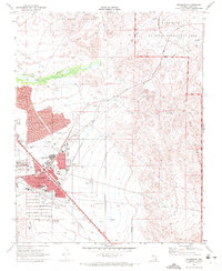 1970 Henderson1972 Print · USGSHenderson and the southeastern Las Vegas Valley appear here at the start of the 1970s, showcasing a growing desert city. Researchers can trace local neighborhoods like Carver Park, industrial landmarks such as the Three Kids Mine, and the route of the Union Pacific railroad.4 unique versions available
 - 1973 Map of Henderson, 1977 Print
 1973 Henderson1977 Print · USGSSouthern Nevada during the early seventies is captured here as the desert landscape around Henderson began to undergo rapid transformation. Trace the development of residential grids alongside the Union Pacific tracks and the natural drainage of the Las Vegas Wash.
 - 1987 Map of Lake Mead, 1988 Print
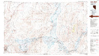 1987 Lake Mead1988 Print · USGSThe Lake Mead region in the late eighties shows a landscape shaped by massive water reclamation and growing desert communities. Trace the reach of the reservoir from Hoover Dam to Meadview, or locate remote desert landmarks like Rogers Spring and the Bowl of Fire.
End of results
Showing maps 1-9 of 9
Frequently asked questions
- What are the different types of historical maps available for Tuscany Residential Village?
- What is the oldest map of Tuscany Residential Village?
- Where can I purchase historical maps of Tuscany Residential Village for my home or office?
- Where can I download high-res historical maps of Tuscany Residential Village?
- Are there historical topographic maps available for Tuscany Residential Village?
- Is there historical aerial imagery available for Tuscany Residential Village?
- Where are historical maps of Tuscany Residential Village sourced from?