
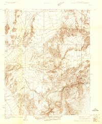
1926 Map of Boulder Canyon
USGS Topo · Published 1926About this map
Boulder Canyon Dam Site and the proposed Hoover Dam Site represent a critical moment in the history of the American Southwest, appearing here just years before construction began. This survey by the City of Los Angeles focuses on the drainage and topography of the Colorado River and the emerging Lake Mead basin along the Nevada-Arizona border. The map documents the arid terrain of Bitter Spring Valley and Dry Lake Valley, punctuated by landmarks like Muddy Pk and Fortification Hill. Inland, the Union Pacific railroad corridor supports small railway stops such as Apex, Dike, and Garnet. The inclusion of the Boulder Rapids and the settlement of Bonelli provides a view of the river's original state before the massive hydrological engineering projects transformed the region permanently.
Find a feature on this map
21 named features on this map. Tap any name to fly to it.
Don’t see what you’re looking for? This feature index may not catch every label — zoom into the map to look around manually.
Map Details
Editions of this 1926 Boulder Canyon Map
2 editions found
Other maps of this area

1886 · Camp Mohave
USGS Topo · 1:250,000

1886 · Saint Thomas
USGS Topo · 1:250,000

1892 · Camp Mohave
USGS Topo · 1:250,000

1893 · Saint Thomas
USGS Topo · 1:250,000

1907 · Las Vegas
USGS Topo · 1:250,000

1908 · Las Vegas
USGS Topo · 1:250,000

1910 · Ivanpah
USGS Topo · 1:250,000

1912 · Ivanpah
USGS Topo · 1:250,000

1926 · Nelson
USGS Topo · 1:96,000

1926 · Bonelli
USGS Topo · 1:96,000