1980s Maps of Grapevine Villas, Mesquite
Explore 2 historic maps of Grapevine Villas from the 1980s. These maps offer a rare glimpse into what life looked like during the 1980s — showing old roads, neighborhoods, homes, and landmarks that have changed or disappeared over time.
Whether you're researching your family's past, planning a metal detecting trip, or studying how Grapevine Villas's landscape evolved across the 1980s, these high-resolution maps are a powerful tool for exploring the history of this region.
- Focus on a specific era: All maps on this page are from the 1980s, giving you a focused view of this time period.
- See what’s changed: Compare century-old streets, trails, and buildings to today's modern landscape using overlays and satellite layers.
- Research with precision: Use these maps for genealogy, historical research, land use analysis, or educational projects.
- View, download, or print: Maps are fully viewable online in high resolution, and can be downloaded or printed for your own records.
Start exploring Grapevine Villas's history through authentic maps from the 1980s. This is your window into the past.
Grapevine Villas, Mesquite maps
(2)- 1985 Map of Mesquite
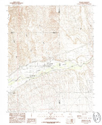 1985 Mesquite1985 Print · USGSThe Virgin River valley at the Nevada-Arizona border shows its agricultural roots and desert landscape in the mid-eighties. Genealogists and researchers can trace local infrastructure through the Mesquite Flume Ditch and locations like the Cem and Bunkerville.
 - 1987 Map of Overton, 1988 Print
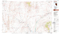 1987 Overton1988 Print · USGSSoutheastern Nevada at the end of the 1980s reveals a desert landscape of river-valley settlements and vast public lands. Trace the Union Pacific line through Moapa or locate family sites in Logandale and Bunkerville along the Virgin River.2 unique versions available
End of results
Showing maps 1-2 of 2
Frequently asked questions
- What are the different types of historical maps available for Grapevine Villas?
- What is the oldest map of Grapevine Villas?
- Where can I purchase historical maps of Grapevine Villas for my home or office?
- Where can I download high-res historical maps of Grapevine Villas?
- Are there historical topographic maps available for Grapevine Villas?
- Is there historical aerial imagery available for Grapevine Villas?
- Where are historical maps of Grapevine Villas sourced from?