1980s Maps of Primm, Nevada
Explore 2 historic maps of Primm from the 1980s. These maps offer a rare glimpse into what life looked like during the 1980s — showing old roads, neighborhoods, homes, and landmarks that have changed or disappeared over time.
Whether you're researching your family's past, planning a metal detecting trip, or studying how Primm's landscape evolved across the 1980s, these high-resolution maps are a powerful tool for exploring the history of this region.
- Focus on a specific era: All maps on this page are from the 1980s, giving you a focused view of this time period.
- See what’s changed: Compare century-old streets, trails, and buildings to today's modern landscape using overlays and satellite layers.
- Research with precision: Use these maps for genealogy, historical research, land use analysis, or educational projects.
- View, download, or print: Maps are fully viewable online in high resolution, and can be downloaded or printed for your own records.
Start exploring Primm's history through authentic maps from the 1980s. This is your window into the past.
Primm, NV maps
(2)- 1985 Map of Mesquite Lake
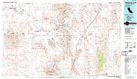 1985 Mesquite Lake1985 Print · USGSThe high desert along the Nevada-California line is captured here in the mid-1980s, showcasing a landscape defined by historic mining and transit. Researchers can trace numerous old claims like the Potosi Mine and Yellow Pine Mine or follow the historic Old Spanish Trail.2 unique versions available
 - 1985 Map of Ivanpah Lake
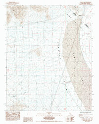 1985 Ivanpah Lake1985 Print · USGSThe high desert along the California-Nevada border is captured here in the mid-eighties, showing a landscape defined by mountain ranges and dry lake beds. Researchers can trace the historic Boundary (1873) and locate isolated desert features like Yates Well and the Umberci Mine.
End of results
Showing maps 1-2 of 2
Top cities near Primm
Frequently asked questions
- What are the different types of historical maps available for Primm?
- What is the oldest map of Primm?
- Where can I purchase historical maps of Primm for my home or office?
- Where can I download high-res historical maps of Primm?
- Are there historical topographic maps available for Primm?
- Is there historical aerial imagery available for Primm?
- Where are historical maps of Primm sourced from?