1980s Maps of Stewarts Point, Nevada
Explore 2 historic maps of Stewarts Point from the 1980s. These maps offer a rare glimpse into what life looked like during the 1980s — showing old roads, neighborhoods, homes, and landmarks that have changed or disappeared over time.
Whether you're researching your family's past, planning a metal detecting trip, or studying how Stewarts Point's landscape evolved across the 1980s, these high-resolution maps are a powerful tool for exploring the history of this region.
- Focus on a specific era: All maps on this page are from the 1980s, giving you a focused view of this time period.
- See what’s changed: Compare century-old streets, trails, and buildings to today's modern landscape using overlays and satellite layers.
- Research with precision: Use these maps for genealogy, historical research, land use analysis, or educational projects.
- View, download, or print: Maps are fully viewable online in high resolution, and can be downloaded or printed for your own records.
Start exploring Stewarts Point's history through authentic maps from the 1980s. This is your window into the past.
Stewarts Point, NV maps
(2)- 1984 Map of Valley of Fire East
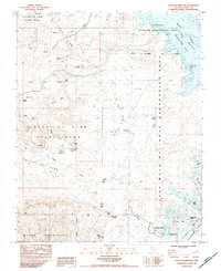 1984 Valley of Fire East1984 Print · USGSThe eastern reaches of the Nevada desert met the rising waters of Lake Mead in the early 1980s, revealing a landscape of historic travel and industrial mining. You can locate the Grave Cpt John J Clark Memorial Monument and trace early desert resource extraction at Florence Mine No 1.2 unique versions available
 - 1987 Map of Lake Mead, 1988 Print
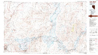 1987 Lake Mead1988 Print · USGSThe Lake Mead region in the late eighties shows a landscape shaped by massive water reclamation and growing desert communities. Trace the reach of the reservoir from Hoover Dam to Meadview, or locate remote desert landmarks like Rogers Spring and the Bowl of Fire.
End of results
Showing maps 1-2 of 2
Top cities near Stewarts Point
Frequently asked questions
- What are the different types of historical maps available for Stewarts Point?
- What is the oldest map of Stewarts Point?
- Where can I purchase historical maps of Stewarts Point for my home or office?
- Where can I download high-res historical maps of Stewarts Point?
- Are there historical topographic maps available for Stewarts Point?
- Is there historical aerial imagery available for Stewarts Point?
- Where are historical maps of Stewarts Point sourced from?