1900s (20th Century) Maps of Carlin, Nevada
Explore 8 historic maps of Carlin from the 1900s (20th Century). These maps offer a rare glimpse into what life looked like during the 1900s — showing old roads, neighborhoods, homes, and landmarks that have changed or disappeared over time.
Whether you're researching your family's past, planning a metal detecting trip, or studying how Carlin's landscape evolved across the 1900s, these high-resolution maps are a powerful tool for exploring the history of this region.
- Focus on a specific era: All maps on this page are from the 1900s, giving you a focused view of this time period.
- See what’s changed: Compare century-old streets, trails, and buildings to today's modern landscape using overlays and satellite layers.
- Research with precision: Use these maps for genealogy, historical research, land use analysis, or educational projects.
- View, download, or print: Maps are fully viewable online in high resolution, and can be downloaded or printed for your own records.
Start exploring Carlin's history through authentic maps from the 1900s. This is your window into the past.
Carlin, NV maps
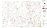
(8)- 1952 Map of Carlin, 1954 Print
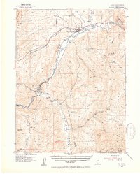 1952 Carlin1954 Print · USGSThe Nevada high desert meets the iron rail in the early 1950s as the Southern Pacific and Western Pacific navigate the Humboldt River corridor. Researchers can trace historic routes like the California Trail or locate family sites like Raine Ranch and Thomas Place.5 unique versions available
 - 1955 Map of Winnemucca, 1968 Print
 1955 Winnemucca1968 Print · USGSNorthern Nevada's high desert corridor is captured here in the mid-fifties, centered on the river-and-rail hub of Winnemucca. Researchers can trace the dual tracks of the Southern Pacific and Western Pacific railroads through towns like Golconda and Valmy.3 unique versions available
 - 1958 Map of Winnemucca
 1958 Winnemucca1958 Print · USGSNorthern Nevada in the late fifties was defined by the parallel rhythms of the great transcontinental railroads and a resilient mining industry. Genealogists and historians can trace old mining camps and remote rail sidings from Gold Acres and Palisade to the Adelaide district.2 unique versions available
 - 1962 Map of Winnemucca
 1962 Winnemucca1962 Print · USGSNorthern Nevada's high desert comes alive in the mid-1950s as a vital transportation and mining corridor following the Humboldt River. Trace the early rail-and-ranch economy through stops like Palisade, find old workings at the Adelaide Mine, and see the layout of Winnemucca before the interstate era.
 - 1975 Map of Carlin NE, 1979 Print
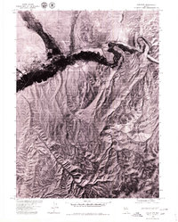 1975 Carlin NE1979 Print · USGSThe high desert landscape around the town of Carlin in the mid-1970s is captured here in sharp aerial detail. Researchers can trace the path of the Humboldt River through Carlin Canyon and identify remote terrain landmarks like Buckskin Mtn.
 - 1985 Map of Carlin East, 1986 Print
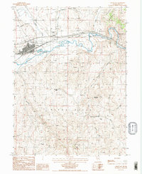 1985 Carlin East1986 Print · USGSElko County at the mid-eighties shows the critical transport corridor along the Humboldt River and the growing hub of Carlin. Researchers can trace the legacy of mining and transit through sites like the Carlin Airfield, Mineshaft Mines, and the Cem near the river fork.2 unique versions available
 - 1985 Map of Carlin West, 1986 Print
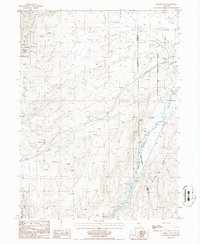 1985 Carlin West1986 Print · USGSThe high desert of Eureka County during the mid-eighties shows a landscape defined by the Humboldt River and ranching infrastructure. Trace the settlement of Tyrol, find remote water sources like Warm Spring, and locate numerous Prospects tucked into the Pinon Range.
 - 1988 Map of Battle Mountain
 1988 Battle Mountain1988 Print · USGSNorth-central Nevada in the late eighties shows a landscape deeply tied to the Humboldt River and its heavy rail corridors. Trace the path of the Southern Pacific through high-desert hubs like Battle Mountain, Beowawe, and the Schroeder Mountain Mine.
End of results
Showing maps 1-8 of 8
Frequently asked questions
- What are the different types of historical maps available for Carlin?
- What is the oldest map of Carlin?
- Where can I purchase historical maps of Carlin for my home or office?
- Where can I download high-res historical maps of Carlin?
- Are there historical topographic maps available for Carlin?
- Is there historical aerial imagery available for Carlin?
- Where are historical maps of Carlin sourced from?