1980s Maps of Dry Creek, Nevada
Explore 2 historic maps of Dry Creek from the 1980s. These maps offer a rare glimpse into what life looked like during the 1980s — showing old roads, neighborhoods, homes, and landmarks that have changed or disappeared over time.
Whether you're researching your family's past, planning a metal detecting trip, or studying how Dry Creek's landscape evolved across the 1980s, these high-resolution maps are a powerful tool for exploring the history of this region.
- Focus on a specific era: All maps on this page are from the 1980s, giving you a focused view of this time period.
- See what’s changed: Compare century-old streets, trails, and buildings to today's modern landscape using overlays and satellite layers.
- Research with precision: Use these maps for genealogy, historical research, land use analysis, or educational projects.
- View, download, or print: Maps are fully viewable online in high resolution, and can be downloaded or printed for your own records.
Start exploring Dry Creek's history through authentic maps from the 1980s. This is your window into the past.
Dry Creek, NV maps
(2)- 1985 Map of Green Mountain, 1986 Print
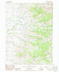 1985 Green Mountain1986 Print · USGSElko County high-altitude ranching and wilderness are captured here in the mid-eighties, showcasing the remote life of the Great Basin. Genealogists and historians can locate family outposts like Smith Creek Ranch and Merkley Ranch or trace the rugged Smith Creek Trail.
 - 1988 Map of Ruby Lake
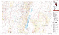 1988 Ruby Lake1988 Print · USGSThe Ruby Mountains and surrounding desert valleys are captured here in the late eighties, showing a landscape of high-altitude passes and vital wetlands. Genealogists and researchers can trace remote sites like Jiggs, Indian Village, and the Ruby Lake National Wildlife Refuge.2 unique versions available
End of results
Showing maps 1-2 of 2
Frequently asked questions
- What are the different types of historical maps available for Dry Creek?
- What is the oldest map of Dry Creek?
- Where can I purchase historical maps of Dry Creek for my home or office?
- Where can I download high-res historical maps of Dry Creek?
- Are there historical topographic maps available for Dry Creek?
- Is there historical aerial imagery available for Dry Creek?
- Where are historical maps of Dry Creek sourced from?