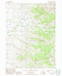
1985 Map of Green Mountain
USGS Topo · Published 1986About this map
Ruby Mountains high-country terrain dominates this mid-1980s survey, revealing a landscape defined by seasonal water management and remote high-altitude ranching. The eastern half of the map is occupied by the protected lands of the Humboldt National Forest, where steep slopes rise toward Green Mountain. At the base of these peaks, a series of ranching operations including Smith Creek Ranch, Riordan Ranch, and Merkley Ranch utilize complex irrigation systems fed by descending mountain streams. A notable Landing Strip at Smith Creek Ranch underscores the isolation of these outposts. The network of drainage, from the North Fork Smith Creek to the smaller Carville Creek, creates a distinct pattern of human activity concentrated along the narrow valley floors. This provisional edition documents the intricate drainage and trails, like the Smith Creek Trail, that provided access to the high basins and Lost Lake before modern development altered the land.
Find a feature on this map
22 named features on this map. Tap any name to fly to it.
Don’t see what you’re looking for? This feature index may not catch every label — zoom into the map to look around manually.
Map Details
Editions of this 1985 Green Mountain Map
This is the sole edition of this map. No revisions or reprints were ever made.
Other maps of this area

1934 · Jiggs
USGS Topo · 1:125,000

1935 · Halleck
USGS Topo · 1:125,000

1937 · Jiggs
USGS Topo · 1:125,000

1955 · Elko
USGS Topo · 1:250,000

1958 · Elko
USGS Topo · 1:250,000

1959 · Jiggs
USGS Topo · 1:62,500

1962 · Elko
USGS Topo · 1:250,000

1962 · Lee
USGS Topo · 1:62,500

1962 · Lamoille
USGS Topo · 1:62,500

1965 · Elko
USGS Topo · 1:250,000