
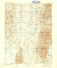
1937 Map of Jiggs
USGS Topo · Published 1937About this map
Mound Valley and the surrounding high desert basins are depicted here as they appeared in the mid-1930s, showing a landscape defined by isolated family ranches and rugged mountain passes. The small settlement of Jiggs sits at the junction of several drainage routes, including Huntington Creek and Mc Cutcheon Creek. To the east, the Diamond Mts and the Ruby Valley region provide a backdrop for high-altitude landmarks like Pearl Peak and Sherman Mtn. This survey reveals the cattle and sheep ranching economy of the era through the naming of numerous properties such as the Sestanovich Ranch, Goyeneche Ranch, and Hylton Ranch. Transportation in this portion of Elko Co relies on critical crossings like Harrison Pass and Overland Pass, while local services are anchored by the Smith Creek Sch and the Harrison Pass Ranger Sta.
Find a feature on this map
82 named features on this map. Tap any name to fly to it.
Don’t see what you’re looking for? This feature index may not catch every label — zoom into the map to look around manually.
Map Details
Editions of this 1937 Jiggs Map
2 editions found
Other maps of this area

1926 · Roberts Mountains
USGS Topo · 1:250,000

1929 · Roberts Mountains
USGS Topo · 1:250,000

1934 · Jiggs
USGS Topo · 1:125,000

1935 · Halleck
USGS Topo · 1:125,000

1937 · Mineral Hill
USGS Topo · 1:48,000

1943 · Mineral Hill
USGS Topo · 1:62,500

1949 · Garden Valley
USGS Topo · 1:62,500

1951 · Garden Valley
USGS Topo · 1:62,500

1952 · Dixie Flats
USGS Topo · 1:62,500

1952 · Pine Valley
USGS Topo · 1:62,500