
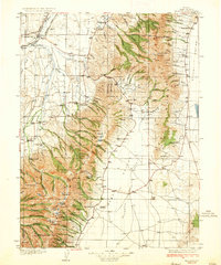
1934 Map of Jiggs
USGS Topo · Published 1955About this map
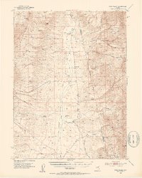
Mound Valley and the surrounding high desert of Elko County are defined by a network of family-run operations during the mid-1930s. The settlement at Jiggs serves as a central hub for the dispersed cattle ranching community, where names like Zunino, Hylton, and Bestanovich mark the drainage of Huntington Creek. To the east, the Ruby Mountains rise sharply, anchored by Pearl Peak and the remote Harrison Pass Ranger Station. The map illustrates a landscape of high-altitude life, from the Smith Creek School to the Davis Ranch Hobson Post Office near the White Pine County line. In the southwest, the barren expanse of Diamond Alkali Flat contrasts with the intricate creek systems like Cottonwood Creek and Pearl Creek that fed the valley's agricultural viability.
Find a feature on this map
89 named features on this map. Tap any name to fly to it.
Don’t see what you’re looking for? This feature index may not catch every label — zoom into the map to look around manually.
Map Details
Editions of this 1934 Jiggs Map
This is the sole edition of this map. No revisions or reprints were ever made.
Other maps of this area

1926 · Roberts Mountains
USGS Topo · 1:250,000

1929 · Roberts Mountains
USGS Topo · 1:250,000
1935 · Halleck
USGS Topo · 1:125,000
1937 · Mineral Hill
USGS Topo · 1:48,000

1937 · Jiggs
USGS Topo · 1:125,000

1943 · Mineral Hill
USGS Topo · 1:62,500
1949 · Garden Valley
USGS Topo · 1:62,500
1951 · Garden Valley
USGS Topo · 1:62,500

1952 · Dixie Flats
USGS Topo · 1:62,500
1952 · Pine Valley
USGS Topo · 1:62,500