1965 Map of Elko
USGS Topo · Published 1965About this map
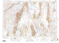
The Humboldt River corridor serves as the primary artery through this high-desert basin and range landscape, where the city of Elko sits at the junction of the Elko Hills and the Adobe Range. In the mid-1960s, the region's transportation network was defined by the parallel tracks of the Southern Pacific and Western Pacific railroads, which connected smaller sidings and stations like Halleck Station and Shafter. The eastern portion of the map is dominated by the Wendover Bombing and Gunnery Range, illustrating the massive scale of military land use on the edge of the Desert during the Cold War era.
Find a feature on this map
64 named features on this map. Tap any name to fly to it.
Don’t see what you’re looking for? This feature index may not catch every label — zoom into the map to look around manually.
Map Details
Editions of this 1965 Elko Map
This is the sole edition of this map. No revisions or reprints were ever made.
Historical Maps of Elko Through Time
5 maps found