1940s Maps of Jarbidge, Nevada
Explore 2 historic maps of Jarbidge from the 1940s. These maps offer a rare glimpse into what life looked like during the 1940s — showing old roads, neighborhoods, homes, and landmarks that have changed or disappeared over time.
Whether you're researching your family's past, planning a metal detecting trip, or studying how Jarbidge's landscape evolved across the 1940s, these high-resolution maps are a powerful tool for exploring the history of this region.
- Focus on a specific era: All maps on this page are from the 1940s, giving you a focused view of this time period.
- See what’s changed: Compare century-old streets, trails, and buildings to today's modern landscape using overlays and satellite layers.
- Research with precision: Use these maps for genealogy, historical research, land use analysis, or educational projects.
- View, download, or print: Maps are fully viewable online in high resolution, and can be downloaded or printed for your own records.
Start exploring Jarbidge's history through authentic maps from the 1940s. This is your window into the past.
Jarbidge, NV maps
(2)- 1943 Map of Jarbidge, 1954 Print
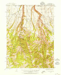 1943 Jarbidge1954 Print · USGSThe Jarbidge mining district in northern Elko County was still a remote outpost of industry and ranching in the 1940s. Genealogists and historians can trace the locations of the Altitude Mine, family operations at Larios Ranch, and the Mahoney Ranger Sta.3 unique versions available
 - 1945 Map of Jarbidge
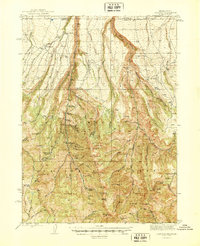 1945 Jarbidge1945 Print · USGSElko County, Nevada, during the mid-1940s reveals a high-country mining district centered on the town of Jarbidge. Researchers can trace the legacy of gold and silver extraction at the Success Mine or locate family-named sites like Larios Ranch.2 unique versions available
End of results
Showing maps 1-2 of 2
Frequently asked questions
- What are the different types of historical maps available for Jarbidge?
- What is the oldest map of Jarbidge?
- Where can I purchase historical maps of Jarbidge for my home or office?
- Where can I download high-res historical maps of Jarbidge?
- Are there historical topographic maps available for Jarbidge?
- Is there historical aerial imagery available for Jarbidge?
- Where are historical maps of Jarbidge sourced from?