1900s (20th Century) Maps of Lamoille, Nevada
Explore 8 historic maps of Lamoille from the 1900s (20th Century). These maps offer a rare glimpse into what life looked like during the 1900s — showing old roads, neighborhoods, homes, and landmarks that have changed or disappeared over time.
Whether you're researching your family's past, planning a metal detecting trip, or studying how Lamoille's landscape evolved across the 1900s, these high-resolution maps are a powerful tool for exploring the history of this region.
- Focus on a specific era: All maps on this page are from the 1900s, giving you a focused view of this time period.
- See what’s changed: Compare century-old streets, trails, and buildings to today's modern landscape using overlays and satellite layers.
- Research with precision: Use these maps for genealogy, historical research, land use analysis, or educational projects.
- View, download, or print: Maps are fully viewable online in high resolution, and can be downloaded or printed for your own records.
Start exploring Lamoille's history through authentic maps from the 1900s. This is your window into the past.
Lamoille, NV maps
(8)- 1935 Map of Halleck
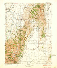 1935 Halleck1935 Print · USGSElko County cattle country and high mountain basins are captured here during the mid-thirties, showing the transition from frontier outposts to a ranching economy. Genealogists can trace family holdings like the Starr Ranch or locate the site of Fort Halleck and various rural schoolhouses.3 unique versions available
 - 1955 Map of Elko, 1974 Print
 1955 Elko1974 Print · USGSNortheastern Nevada in the mid-fifties is captured here as a crossroads of transcontinental rail and high desert ranching. Trace old rail stops from Wells to Elko or find remote landmarks like Shanty Town and Medicine Spring.3 unique versions available
 - 1958 Map of Elko
 1958 Elko1958 Print · USGSNorthern Nevada in the late fifties shows a landscape of high-desert ranching and Cold War aviation. Trace old rail lines like the Nevada Northern or locate the Victoria Mine and Wendover Air Force Base.2 unique versions available
 - 1962 Map of Elko
 1962 Elko1962 Print · USGSNortheastern Nevada in the early sixties is a landscape of mountain ranges and rail corridors, where the river valleys support ranching and transit. Locate old mining operations like Battle Creek Mine, rural stops like Moleen, and the sprawling Wendover Bombing and Gunnery Range.
 - 1962 Map of Lamoille, 1966 Print
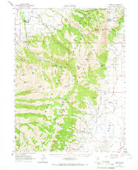 1962 Lamoille1966 Print · USGSThe high alpine peaks and deep canyons of the Ruby Mountains are documented here in the early 1960s. Genealogists and local historians can locate the Ruby Valley School, the Shorty Cemetery, and remote mining operations like the American Beauty Mine.2 unique versions available
 - 1965 Map of Elko
 1965 Elko1965 Print · USGSElko and the northeastern Nevada desert are captured here in the mid-1960s, showcasing a landscape of high ranges and essential rail corridors. Researchers can trace the path of the Western Pacific railroad through small stops like Tobar and Ventosa, or locate remote sites like Shanty Town near the Ruby Lake wetlands.
 - 1986 Map of Elko
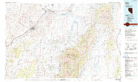 1986 Elko1986 Print · USGSThe Humboldt River basin in the mid-eighties shows a landscape of ranching, transit, and high-desert peaks. Trace the rail-and-road corridor through Elko, or locate remote sites like the Polar Star Mine and South Fork Indian Reservation.
 - 1990 Map of Lamoille
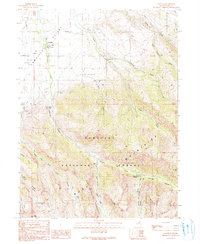 1990 Lamoille1990 Print · USGSLamoille sits at the base of the high mountain ranges during the late twentieth century, where the valley floor meets the canyon mouths. Researchers can trace local landmarks like the Cemetery, the old Power House, and seasonal sites such as Camp Lamoille.2 unique versions available
End of results
Showing maps 1-8 of 8
Top cities near Lamoille
Frequently asked questions
- What are the different types of historical maps available for Lamoille?
- What is the oldest map of Lamoille?
- Where can I purchase historical maps of Lamoille for my home or office?
- Where can I download high-res historical maps of Lamoille?
- Are there historical topographic maps available for Lamoille?
- Is there historical aerial imagery available for Lamoille?
- Where are historical maps of Lamoille sourced from?