1980s Maps of Goldfield, Nevada
Explore 2 historic maps of Goldfield from the 1980s. These maps offer a rare glimpse into what life looked like during the 1980s — showing old roads, neighborhoods, homes, and landmarks that have changed or disappeared over time.
Whether you're researching your family's past, planning a metal detecting trip, or studying how Goldfield's landscape evolved across the 1980s, these high-resolution maps are a powerful tool for exploring the history of this region.
- Focus on a specific era: All maps on this page are from the 1980s, giving you a focused view of this time period.
- See what’s changed: Compare century-old streets, trails, and buildings to today's modern landscape using overlays and satellite layers.
- Research with precision: Use these maps for genealogy, historical research, land use analysis, or educational projects.
- View, download, or print: Maps are fully viewable online in high resolution, and can be downloaded or printed for your own records.
Start exploring Goldfield's history through authentic maps from the 1980s. This is your window into the past.
Goldfield, NV maps
(2)- 1985 Map of Goldfield
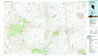 1985 Goldfield1985 Print · USGSEsmeralda County and the surrounding high desert are captured in the mid-eighties as modern infrastructure intersected with a century of mining history. Researchers can locate remote extraction sites like the Mohawk Mine, early outposts at Klondike, and geothermal features like Alkali Hot Spring.
 - 1987 Map of Goldfield, 1988 Print
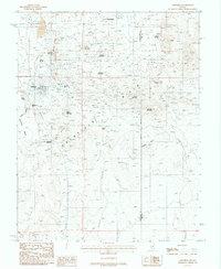 1987 Goldfield1988 Print · USGSThe mining heart of Esmeralda County is captured here in the 1980s, documenting a landscape dense with tunnels and prospect pits. Researchers can trace the lineage of local extraction from Goldfield to Diamondfield, following the Old Railroad Grade past Vindicator Mountain.
End of results
Showing maps 1-2 of 2
Frequently asked questions
- What are the different types of historical maps available for Goldfield?
- What is the oldest map of Goldfield?
- Where can I purchase historical maps of Goldfield for my home or office?
- Where can I download high-res historical maps of Goldfield?
- Are there historical topographic maps available for Goldfield?
- Is there historical aerial imagery available for Goldfield?
- Where are historical maps of Goldfield sourced from?