1960s Maps of Silver Peak, Nevada
Explore 2 historic maps of Silver Peak from the 1960s. These maps offer a rare glimpse into what life looked like during the 1960s — showing old roads, neighborhoods, homes, and landmarks that have changed or disappeared over time.
Whether you're researching your family's past, planning a metal detecting trip, or studying how Silver Peak's landscape evolved across the 1960s, these high-resolution maps are a powerful tool for exploring the history of this region.
- Focus on a specific era: All maps on this page are from the 1960s, giving you a focused view of this time period.
- See what’s changed: Compare century-old streets, trails, and buildings to today's modern landscape using overlays and satellite layers.
- Research with precision: Use these maps for genealogy, historical research, land use analysis, or educational projects.
- View, download, or print: Maps are fully viewable online in high resolution, and can be downloaded or printed for your own records.
Start exploring Silver Peak's history through authentic maps from the 1960s. This is your window into the past.
Silver Peak, NV maps
(2)- 1962 Map of Goldfield
 1962 Goldfield1962 Print · USGSThe Nevada desert during the early sixties reveals a landscape of high-stakes military ranges and waning mining districts. Trace the path of the old railroad grade between Goldfield and Beatty, or locate the isolated sites of Gold Point and Lida.
 - 1963 Map of Silver Peak, 1965 Print
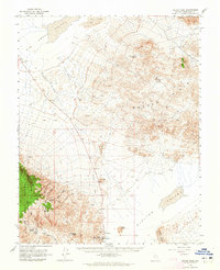 1963 Silver Peak1965 Print · USGSEsmeralda County mining and settlement patterns are frozen in time during the early 1960s as the desert landscape transitions from rail to road. Researchers can trace the Old Railroad Grade past Blair or locate the Mary Mine and Cem near Silver Peak.2 unique versions available
End of results
Showing maps 1-2 of 2
Frequently asked questions
- What are the different types of historical maps available for Silver Peak?
- What is the oldest map of Silver Peak?
- Where can I purchase historical maps of Silver Peak for my home or office?
- Where can I download high-res historical maps of Silver Peak?
- Are there historical topographic maps available for Silver Peak?
- Is there historical aerial imagery available for Silver Peak?
- Where are historical maps of Silver Peak sourced from?