1900s (20th Century) Maps of Paradise Hill, Nevada
Explore 5 historic maps of Paradise Hill from the 1900s (20th Century). These maps offer a rare glimpse into what life looked like during the 1900s — showing old roads, neighborhoods, homes, and landmarks that have changed or disappeared over time.
Whether you're researching your family's past, planning a metal detecting trip, or studying how Paradise Hill's landscape evolved across the 1900s, these high-resolution maps are a powerful tool for exploring the history of this region.
- Focus on a specific era: All maps on this page are from the 1900s, giving you a focused view of this time period.
- See what’s changed: Compare century-old streets, trails, and buildings to today's modern landscape using overlays and satellite layers.
- Research with precision: Use these maps for genealogy, historical research, land use analysis, or educational projects.
- View, download, or print: Maps are fully viewable online in high resolution, and can be downloaded or printed for your own records.
Start exploring Paradise Hill's history through authentic maps from the 1900s. This is your window into the past.
Paradise Hill, NV maps
(5)- 1955 Map of McDermitt
 1955 McDermitt1955 Print · USGSNorthern Nevada in the mid-fifties shows a landscape of mining camps and vast cattle ranges. Trace the early footprints of Tuscarora or the remote Cordero Mine and National Mine tucked into the high desert peaks.3 unique versions available
 - 1958 Map of Paradise Valley, 1960 Print
 1958 Paradise Valley1960 Print · USGSRanching and high-desert peaks define the Nevada landscape in the late fifties, where the high Humboldt National Forest meets the valley floor. Genealogists and historians can trace family properties like Grayson Ranch or locate historical transit markers including Willow Point and Paradise Well.2 unique versions available
 - 1959 Map of McDermitt
 1959 McDermitt1959 Print · USGSThe high-desert borderlands of northern Nevada and southern Oregon are captured here in the late fifties. Researchers can trace historic mining operations at the Cordero Mine and Getchell Mine, or locate settlements like Paradise Valley and Tuscarora.2 unique versions available
 - 1985 Map of Osgood Mts
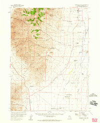
 1985 Osgood Mts1985 Print · USGSHumboldt County in the mid-eighties was a hub of high-desert mining and remote ranching outposts. Trace the industrial footprint of the Getchell Mine, locate historic settlements like Amos, and follow the rail lines through Winnemucca.
 - 1988 Map of Paradise Well, 1989 Print
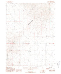 1988 Paradise Well1989 Print · USGSHumboldt County’s high desert comes into focus in the late eighties, showing the remote crossroads of the Santa Rosa Range. Researchers can trace the layout of Paradise Hill and locate mining features like an Adit and various Prospects.
End of results
Showing maps 1-5 of 5
Top cities near Paradise Hill
Frequently asked questions
- What are the different types of historical maps available for Paradise Hill?
- What is the oldest map of Paradise Hill?
- Where can I purchase historical maps of Paradise Hill for my home or office?
- Where can I download high-res historical maps of Paradise Hill?
- Are there historical topographic maps available for Paradise Hill?
- Is there historical aerial imagery available for Paradise Hill?
- Where are historical maps of Paradise Hill sourced from?