1900s (20th Century) Maps of Bristol, Nevada
Explore 6 historic maps of Bristol from the 1900s (20th Century). These maps offer a rare glimpse into what life looked like during the 1900s — showing old roads, neighborhoods, homes, and landmarks that have changed or disappeared over time.
Whether you're researching your family's past, planning a metal detecting trip, or studying how Bristol's landscape evolved across the 1900s, these high-resolution maps are a powerful tool for exploring the history of this region.
- Focus on a specific era: All maps on this page are from the 1900s, giving you a focused view of this time period.
- See what’s changed: Compare century-old streets, trails, and buildings to today's modern landscape using overlays and satellite layers.
- Research with precision: Use these maps for genealogy, historical research, land use analysis, or educational projects.
- View, download, or print: Maps are fully viewable online in high resolution, and can be downloaded or printed for your own records.
Start exploring Bristol's history through authentic maps from the 1900s. This is your window into the past.
Bristol, NV maps
(6)- 1915 Map of Bristol Range, 1955 Print
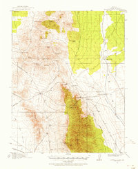 1915 Bristol Range1955 Print · USGSMining camps and narrow-gauge rails define this Nevada landscape during the height of the early 20th-century silver boom. Genealogists and historians can trace the Pioche Pacific (Narrow Gage) railroad through settlements like Jackrabbit and Bristol.2 unique versions available
 - 1917 Map of Bristol Range
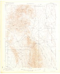 1917 Bristol Range1917 Print · USGSLincoln County mining districts and narrow-gauge rail lines are meticulously preserved in this survey of the Nevada desert during the First World War era. Researchers can trace the industrial infrastructure of Jackrabbit, including its Aerial Tram and the Piocne Pacific Narrow Gage railroad.2 unique versions available
 - 1953 Map of Bristol Range SE, 1955 Print
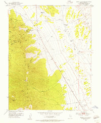 1953 Bristol Range SE1955 Print · USGSMining operations in the Bristol Range were in full swing during the early fifties, defining the economy of this high-desert Nevada landscape. Historians can trace the Old Railroad Grade and locate dozens of specific claims including the Lucky Star Mine, Monarch Mine, and the Bristol School.2 unique versions available
 - 1956 Map of Lund, 1963 Print
 1956 Lund1963 Print · USGSEastern Nevada and the Utah borderlands are mapped here during the mid-fifties, showing a landscape of high-desert ranches and mountain mining camps. Genealogists and historians can trace family locations through sites like Bristol Silver Mines, Lund, and the Sunnyside Whipple Ranch.2 unique versions available
 - 1960 Map of Lund
 1960 Lund1960 Print · USGSEastern Nevada and the Utah borderlands are mapped here during the mid-twentieth century, showing a landscape of high peaks and isolated ranching outposts. Researchers can locate remote mining sites like the Tungsten Queen Mine and early settlements including Lund and Shoshone.
 - 1982 Map of Wilson Creek Range
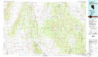 1982 Wilson Creek Range1982 Print · USGSLincoln County mining districts and high-desert basins are captured here in the early eighties as the region balanced mineral production with early conservation. Researchers can trace historic industrial sites like the Atlanta Mine and Bristol Silver Mine or locate remote landmarks such as The Hermitage.
End of results
Showing maps 1-6 of 6
Top cities near Bristol
Frequently asked questions
- What are the different types of historical maps available for Bristol?
- What is the oldest map of Bristol?
- Where can I purchase historical maps of Bristol for my home or office?
- Where can I download high-res historical maps of Bristol?
- Are there historical topographic maps available for Bristol?
- Is there historical aerial imagery available for Bristol?
- Where are historical maps of Bristol sourced from?