1900s (20th Century) Maps of Golden Arrow, Nevada
Explore 9 historic maps of Golden Arrow from the 1900s (20th Century). These maps offer a rare glimpse into what life looked like during the 1900s — showing old roads, neighborhoods, homes, and landmarks that have changed or disappeared over time.
Whether you're researching your family's past, planning a metal detecting trip, or studying how Golden Arrow's landscape evolved across the 1900s, these high-resolution maps are a powerful tool for exploring the history of this region.
- Focus on a specific era: All maps on this page are from the 1900s, giving you a focused view of this time period.
- See what’s changed: Compare century-old streets, trails, and buildings to today's modern landscape using overlays and satellite layers.
- Research with precision: Use these maps for genealogy, historical research, land use analysis, or educational projects.
- View, download, or print: Maps are fully viewable online in high resolution, and can be downloaded or printed for your own records.
Start exploring Golden Arrow's history through authentic maps from the 1900s. This is your window into the past.
Golden Arrow, NV maps
(9)- 1908 Map of Kawich
 1908 Kawich1908 Print · USGSNye County's high-desert mining frontier is documented here just after the turn of the century as camps and rail lines began to stitch together the valleys. You can trace early logistics and family landholdings at Longstreets Ranch, the isolated Gold Reed Kawich PO, and the Bullfrog Goldfield RR junction.3 unique versions available
 - 1942 Map of Cactus Range
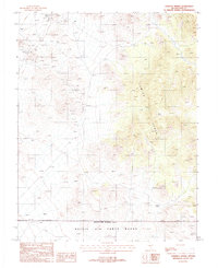
 1942 Cactus Range1942 Print · USGSNye County was undergoing a major military transformation during the early forties as ranching and mining land was repurposed for defense. Researchers can find old desert outposts like Golden Arrow and Trappmans Camp alongside vital water sources such as Antelope Springs and Cactus Spring.
 - 1952 Map of Stinking Spring
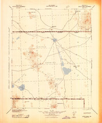
 1952 Stinking Spring1952 Print · USGSNye County ranching and mining gave way to Cold War military operations during the early fifties. Researchers can trace the layout of the Las Vegas Bombing and Gunnery Range alongside older sites like Longstreets Ranch and the Golden Arrow Mining Area.3 unique versions available
 - 1954 Map of Goldfield, 1967 Print
 1954 Goldfield1967 Print · USGSThe Nevada desert during the early Cold War era shows the convergence of traditional mining districts and military expansion. Genealogists and historians can trace the Tonopah and Tidewater Railroad route and locate remote sites like Gold Point and Scottys Castle.3 unique versions available
 - 1955 Map of Goldfield
 1955 Goldfield1955 Print · USGSThe Nevada desert in the mid-fifties reveals a landscape of mining camps and military expansion. You can trace legacy sites from the Klondike Mine to Gold Point, and locate remote outposts like Bonnie Claire and Staininger Ranch at the edge of Death Valley.
 - 1958 Map of Goldfield
 1958 Goldfield1958 Print · USGSThe Nevada-California borderlands in the late fifties show a landscape defined by mining history and emerging military ranges. Researchers can trace old routes to Scotty's Castle, identify the locations of Numerous mines near Gold Point, and find Goldfield at its peak.2 unique versions available
 - 1962 Map of Goldfield
 1962 Goldfield1962 Print · USGSThe Nevada desert during the early sixties reveals a landscape of high-stakes military ranges and waning mining districts. Trace the path of the old railroad grade between Goldfield and Beatty, or locate the isolated sites of Gold Point and Lida.
 - 1987 Map of Stinking Spring, 1988 Print
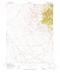
 1987 Stinking Spring1988 Print · USGSThe high desert of Nye County is captured in the late 1980s, revealing a landscape shaped by mineral hunting and military defense. Researchers can locate the mining site at Golden Arrow or trace the remote water source at Stinking Spring near the Nellis Air Force Range.
 - 1988 Map of Cactus Flat, 1989 Print
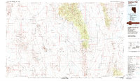 1988 Cactus Flat1989 Print · USGSNye County in the late eighties reveals a stark desert landscape where military operations overlap with old mining history. Researchers can trace the layout of early camps like Silverbow and Jamestown alongside the deep Kawich Depression.
End of results
Showing maps 1-9 of 9
Frequently asked questions
- What are the different types of historical maps available for Golden Arrow?
- What is the oldest map of Golden Arrow?
- Where can I purchase historical maps of Golden Arrow for my home or office?
- Where can I download high-res historical maps of Golden Arrow?
- Are there historical topographic maps available for Golden Arrow?
- Is there historical aerial imagery available for Golden Arrow?
- Where are historical maps of Golden Arrow sourced from?