1900s (20th Century) Maps of Unionville, Nevada
Explore 7 historic maps of Unionville from the 1900s (20th Century). These maps offer a rare glimpse into what life looked like during the 1900s — showing old roads, neighborhoods, homes, and landmarks that have changed or disappeared over time.
Whether you're researching your family's past, planning a metal detecting trip, or studying how Unionville's landscape evolved across the 1900s, these high-resolution maps are a powerful tool for exploring the history of this region.
- Focus on a specific era: All maps on this page are from the 1900s, giving you a focused view of this time period.
- See what’s changed: Compare century-old streets, trails, and buildings to today's modern landscape using overlays and satellite layers.
- Research with precision: Use these maps for genealogy, historical research, land use analysis, or educational projects.
- View, download, or print: Maps are fully viewable online in high resolution, and can be downloaded or printed for your own records.
Start exploring Unionville's history through authentic maps from the 1900s. This is your window into the past.
Unionville, NV maps
(7)- 1931 Map of Lovelock, 1955 Print
 1931 Lovelock1955 Print · USGSPershing County's high-desert mining landscape is frozen in time during the early 1930s, as gold and tungsten districts drove the local economy. Genealogists and historians can trace the foundations of Unionville, the industrial footprint of the Nevada Massachusetts Tungsten Mine, and the route of the Victory Highway.
 - 1935 Map of Lovelock
 1935 Lovelock1935 Print · USGSPershing County in the mid-1930s is a landscape of high-desert mining camps and essential rail hubs along the Humboldt. Researchers can trace the legacy of the silver and tungsten booms at Rochester, the Sulphur Mine, and the now-quiet streets of Unionville or Mazuma.3 unique versions available
 - 1954 Map of Unionville, 1956 Print
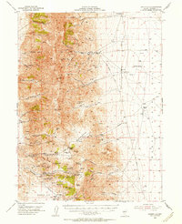 1954 Unionville1956 Print · USGSPershing County mining history is preserved here during the mid-fifties, showing the rugged network of silver camps and trails. You can trace the development of Unionville and Rochester alongside specific operations like the Arizona Mine and Nevada Packard Mines.3 unique versions available
 - 1955 Map of Lovelock, 1963 Print
 1955 Lovelock1963 Print · USGSNorthwestern Nevada’s vast desert basins and military ranges are captured here in the mid-fifties, showing a landscape defined by the Humboldt River and the great Pyramid Lake. Genealogists and historians can trace isolated rail stops like Gerlach and Empire, or locate historic workings such as the Golden Eagle Mine and Pershing Mine.5 unique versions available
 - 1959 Map of Lovelock
 1959 Lovelock1959 Print · USGSNorthwestern Nevada in the late fifties is a study in vast desert basins and isolated rail outposts like Gerlach and Sulphur. You can trace the Humboldt River corridor through Lovelock, identify mid-century military zones, and locate the Mine Mill in the northern ranges.2 unique versions available
 - 1984 Map of Lovelock, 1985 Print
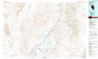 1984 Lovelock1985 Print · USGSThe Humboldt River valley and its flanking silver districts are captured here in the mid-1980s. Genealogists and historians can locate early mining camps like Unionville and Rochester alongside active operations like the Eagle Picher Mine.
 - 1987 Map of Unionville
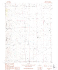 1987 Unionville1987 Print · USGSUnionville is documented here in the late eighties as it served as a gateway between the steep Humboldt Range and the open Buena Vista Valley. Genealogists and historians can trace mining sites like the Black Warrior Mine, search for family names at the cemetery, or locate water sources like Harrison Spring.
End of results
Showing maps 1-7 of 7
Top cities near Unionville
Frequently asked questions
- What are the different types of historical maps available for Unionville?
- What is the oldest map of Unionville?
- Where can I purchase historical maps of Unionville for my home or office?
- Where can I download high-res historical maps of Unionville?
- Are there historical topographic maps available for Unionville?
- Is there historical aerial imagery available for Unionville?
- Where are historical maps of Unionville sourced from?