1980s Maps of Storey County, Nevada
Explore 8 historic maps of Storey County from the 1980s. These maps offer a rare glimpse into what life looked like during the 1980s — showing old roads, neighborhoods, homes, and landmarks that have changed or disappeared over time.
Whether you're researching your family's past, planning a metal detecting trip, or studying how Storey County's landscape evolved across the 1980s, these high-resolution maps are a powerful tool for exploring the history of this region.
- Focus on a specific era: All maps on this page are from the 1980s, giving you a focused view of this time period.
- See what’s changed: Compare century-old streets, trails, and buildings to today's modern landscape using overlays and satellite layers.
- Research with precision: Use these maps for genealogy, historical research, land use analysis, or educational projects.
- View, download, or print: Maps are fully viewable online in high resolution, and can be downloaded or printed for your own records.
Start exploring Storey County's history through authentic maps from the 1980s. This is your window into the past.
Storey County, NV maps
(8)- 1980 Map of Patrick
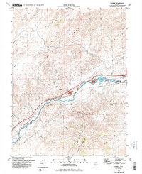 1980 Patrick1980 Print · USGSThe Truckee River canyon serves as a vital industrial artery in the early 1980s, where the high desert meets heavy utility. Researchers can trace the rail-and-river network through Patrick, locating the Tracy Powerplant, the 102 Ranch, and Old Lonesome.
 - 1980 Map of Reno
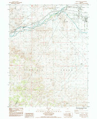
 1980 Reno1980 Print · USGSReno and its high-desert surroundings appear in transition during the 1980s, balancing rapid urban expansion with its deep mining and ranching roots. Genealogists and historians can trace the Southern Pacific line through Fernley or locate local landmarks like Mountain View Cem and the Ruth Mine.3 unique versions available
 - 1985 Map of Misfits Flat
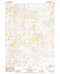
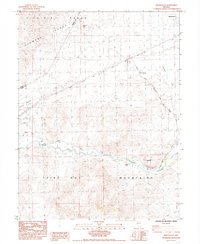 1985 Misfits Flat1985 Print · USGSLyon and Storey counties in the mid-1980s showcase a high-desert landscape shaped by historic migration and irrigation. Genealogists and historians can trace the Emigrant Trail across the Misfits Flat and locate old settlement points like Desert Station.3 unique versions available
 - 1985 Map of Derby Dam
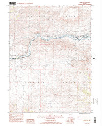 1985 Derby Dam1985 Print · USGSThe Truckee River corridor near the Washoe and Storey County line is shown here in the mid-1980s as a vital transportation and water-management hub. Researchers can trace the path of the Emigrant Trail or locate industrial sites like the Celatom Mine and the historic Derby Dam.2 unique versions available
 - 1985 Map of Stockton Well
 1985 Stockton Well1985 Print · USGSSilver Springs and Churchill Valley emerge in the mid-eighties as an intersection of desert mining history and rural growth. Trace the historic Emigrant Trail past the Tapaloosa (Mining District) or locate family plots at Desert Memorial Gardens.2 unique versions available
 - 1985 Map of Martin Canyon
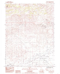
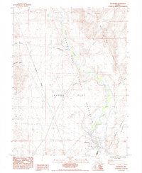
 1985 Martin Canyon1985 Print · USGSStorey and Lyon counties reveal their mining legacy in the mid-eighties as the Virginia and Flowery ranges converge. Local historians can trace the foundations of the Ramsey settlement and locate scattered workings like the Gooseberry Mine and Ramsey Comstock Mine.2 unique versions available
 - 1985 Map of Wadsworth
 1985 Wadsworth1985 Print · USGSThe community of Wadsworth and the Truckee River corridor are captured in the mid-1980s, marking the edge of the Fortymile Desert. Researchers can trace the Southern Pacific rail line, two cemeteries, and the Pyramid Lake Indian Reservation Boundary.3 unique versions available
 - 1985 Map of Fernley West
 1985 Fernley West1985 Print · USGSNear the intersection of Lyon, Washoe, and Storey counties in the mid-1980s, the river and rail lines converge to shape local industry. Genealogists and historians can trace the development of Fernley and the industrial infrastructure surrounding the Truckee River and its Diversion Dam.2 unique versions available
End of results
Showing maps 1-8 of 8
Top cities of Storey County
Frequently asked questions
- What are the different types of historical maps available for Storey County?
- What is the oldest map of Storey County?
- Where can I purchase historical maps of Storey County for my home or office?
- Where can I download high-res historical maps of Storey County?
- Are there historical topographic maps available for Storey County?
- Is there historical aerial imagery available for Storey County?
- Where are historical maps of Storey County sourced from?