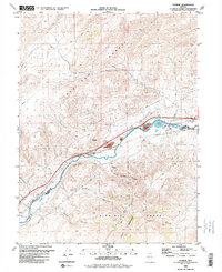
1980 Map of Patrick
USGS Topo · Published 1980About this map
The Truckee River carves a narrow industrial and transportation corridor through the high desert between the Pah Rah Range and the Virginia Range. By the early 1980s, this rugged landscape in Washoe and Storey Counties was anchored by heavy infrastructure, including the Tracy Powerplant, its associated Tracy Pond, and a Gaging Station. The Southern Pacific railroad follows the river's bend, serving as the primary lifeline through the canyon alongside early ranching outposts like 102 Ranch and the small settlement at Patrick.
Find a feature on this map
24 named features on this map. Tap any name to fly to it.
Don’t see what you’re looking for? This feature index may not catch every label — zoom into the map to look around manually.
Map Details
Editions of this 1980 Patrick Map
This is the sole edition of this map. No revisions or reprints were ever made.
Other maps of this area

1890 · Wadsworth
USGS Topo · 1:125,000

1891 · Carson
USGS Topo · 1:125,000

1891 · Wabuska
USGS Topo · 1:125,000

1891 · Reno
USGS Topo · 1:125,000

1892 · Wadsworth
USGS Topo · 1:125,000

1893 · Carson
USGS Topo · 1:125,000

1893 · Reno
USGS Topo · 1:125,000

1894 · Wadsworth
USGS Topo · 1:125,000

1894 · Wabuska
USGS Topo · 1:125,000

1950 · Virginia City
USGS Topo · 1:62,500