
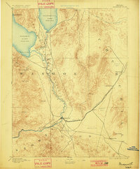
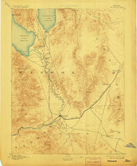
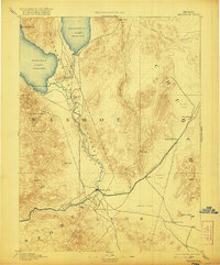
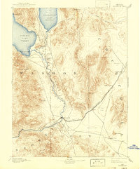
1894 Map of Wadsworth
USGS Topo · Published 1894About this map
Wadsworth serves as the primary hub in this late nineteenth-century survey, situated where the Central Pacific Railroad meets the Truckee River. The map reveals a landscape defined by the hydrography of the Great Basin, dominated by Pyramid Lake and Winnemucca Lake at the northern edge. The presence of the Pyramid Lake Indian Reservation and the Piute Indian Agency marks the cultural geography of the era, while industrial activity is noted at the Eagle Salt Works near the edge of the vast Alkali Flat. To the east, the rail line stretches toward the isolated station at Desert, passing through terrain where geothermal activity is indicated by Hot Springs. This period captures the region's reliance on both the river system and the transcontinental rail corridor before modern water management significantly altered the levels of the terminal lakes.
Find a feature on this map
31 named features on this map. Tap any name to fly to it.
Don’t see what you’re looking for? This feature index may not catch every label — zoom into the map to look around manually.
Map Details
Editions of this 1894 Wadsworth Map
5 editions found
Other maps of this area

1886 · Granite Range
USGS Topo · 1:250,000

1890 · Wadsworth
USGS Topo · 1:125,000

1891 · Carson
USGS Topo · 1:125,000

1891 · Wabuska
USGS Topo · 1:125,000

1891 · Reno
USGS Topo · 1:125,000

1892 · Wadsworth
USGS Topo · 1:125,000

1893 · Carson
USGS Topo · 1:125,000

1893 · Reno
USGS Topo · 1:125,000

1894 · Granite Range
USGS Topo · 1:250,000

1894 · Wabuska
USGS Topo · 1:125,000