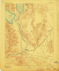
1894 Map of Wadsworth
USGS Topo · Published 1906About this map
Wadsworth serves as the primary hub in this late nineteenth-century desert landscape, situated at the junction of the Central Pacific Railroad and the Truckee River. The map illustrates a period when the Great Basin economy relied heavily on rail transport and localized extraction, evidenced by the Eagle Salt Works located along the eastern tracks. To the north, the Pyramid Lake Indian Reservation encompasses both Pyramid Lake and Winnemucca Lake, with the Piute Indian Agency positioned between them. This survey reflects the hydrographic reality of the era, showing the connection between the lakes via the Slough and Truckee River Outlet. The surrounding terrain is marked by prominent peaks like Pah Rah Mountain and Virginia Peak, while vast stretches of Alkali Flat dominate the lowlands of Churchill and Lyon counties.
Find a feature on this map
30 named features on this map. Tap any name to fly to it.
Don’t see what you’re looking for? This feature index may not catch every label — zoom into the map to look around manually.
Map Details
Editions of this 1894 Wadsworth Map
5 editions found
Other maps of this area

1886 · Granite Range
USGS Topo · 1:250,000

1890 · Wadsworth
USGS Topo · 1:125,000

1891 · Carson
USGS Topo · 1:125,000

1891 · Wabuska
USGS Topo · 1:125,000

1891 · Reno
USGS Topo · 1:125,000

1892 · Wadsworth
USGS Topo · 1:125,000

1893 · Carson
USGS Topo · 1:125,000

1893 · Reno
USGS Topo · 1:125,000

1894 · Granite Range
USGS Topo · 1:250,000

1894 · Wadsworth
USGS Topo · 1:125,000