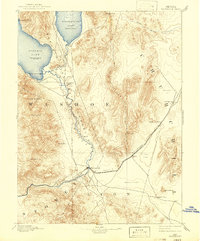
1894 Map of Wadsworth
USGS Topo · Published 1942About this map
The Truckee River carves a critical path through the high desert of western Nevada, flowing northward toward the Truckee River Outlet and into the massive basin of Pyramid Lake. This landscape is centered on the Pyramid Lake Indian Reservation, where the Piute Indian Agency and the settlement of Gibson sat along the river's lower reach. To the east, the now-dry basin of Winnemucca Lake is shown with water, providing a rare look at the region's hydrology before significant upstream diversions altered these terminal lakes.
Find a feature on this map
30 named features on this map. Tap any name to fly to it.
Don’t see what you’re looking for? This feature index may not catch every label — zoom into the map to look around manually.
Map Details
Editions of this 1894 Wadsworth Map
5 editions found
Other maps of this area

1886 · Granite Range
USGS Topo · 1:250,000

1890 · Wadsworth
USGS Topo · 1:125,000

1891 · Carson
USGS Topo · 1:125,000

1891 · Wabuska
USGS Topo · 1:125,000

1891 · Reno
USGS Topo · 1:125,000

1892 · Wadsworth
USGS Topo · 1:125,000

1893 · Carson
USGS Topo · 1:125,000

1893 · Reno
USGS Topo · 1:125,000

1894 · Granite Range
USGS Topo · 1:250,000

1894 · Wadsworth
USGS Topo · 1:125,000