1900s (20th Century) Maps of Deep Hole, Nevada
Explore 5 historic maps of Deep Hole from the 1900s (20th Century). These maps offer a rare glimpse into what life looked like during the 1900s — showing old roads, neighborhoods, homes, and landmarks that have changed or disappeared over time.
Whether you're researching your family's past, planning a metal detecting trip, or studying how Deep Hole's landscape evolved across the 1900s, these high-resolution maps are a powerful tool for exploring the history of this region.
- Focus on a specific era: All maps on this page are from the 1900s, giving you a focused view of this time period.
- See what’s changed: Compare century-old streets, trails, and buildings to today's modern landscape using overlays and satellite layers.
- Research with precision: Use these maps for genealogy, historical research, land use analysis, or educational projects.
- View, download, or print: Maps are fully viewable online in high resolution, and can be downloaded or printed for your own records.
Start exploring Deep Hole's history through authentic maps from the 1900s. This is your window into the past.
Deep Hole, NV maps
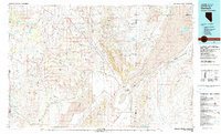
(5)- 1955 Map of Lovelock, 1963 Print
 1955 Lovelock1963 Print · USGSNorthwestern Nevada’s vast desert basins and military ranges are captured here in the mid-fifties, showing a landscape defined by the Humboldt River and the great Pyramid Lake. Genealogists and historians can trace isolated rail stops like Gerlach and Empire, or locate historic workings such as the Golden Eagle Mine and Pershing Mine.5 unique versions available
 - 1959 Map of Lovelock
 1959 Lovelock1959 Print · USGSNorthwestern Nevada in the late fifties is a study in vast desert basins and isolated rail outposts like Gerlach and Sulphur. You can trace the Humboldt River corridor through Lovelock, identify mid-century military zones, and locate the Mine Mill in the northern ranges.2 unique versions available
 - 1964 Map of Gerlach, 1966 Print
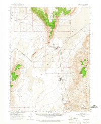 1964 Gerlach1966 Print · USGSWashoe and Pershing counties meet in the high desert during the mid-sixties, where the railroad and ranching life intersect. Genealogists and historians can locate remote sites like Deephole Ranch, the Gerlach Cem, and the industrial layout of Empire.2 unique versions available
 - 1981 Map of Gerlach
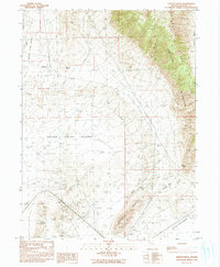
 1981 Gerlach1981 Print · USGSThe high desert of northwestern Nevada and eastern California is mapped here during the early eighties, centered on the vital rail and mining hub of Gerlach. Researchers can trace the Western Pacific corridor through Trego and locate remote operations like the Arcturus Mine and the gypsum works at Empire.2 unique versions available
 - 1990 Map of Godeys Rock
 1990 Godeys Rock1990 Print · USGSWashoe County's high desert reaches and mountain ranges are documented here as they appeared in the 1990s. Researchers can trace land use at Deephole Ranch, locate the settlement at Phil, and follow the terrain through Godeys Gap.
End of results
Showing maps 1-5 of 5
Top cities near Deep Hole
Frequently asked questions
- What are the different types of historical maps available for Deep Hole?
- What is the oldest map of Deep Hole?
- Where can I purchase historical maps of Deep Hole for my home or office?
- Where can I download high-res historical maps of Deep Hole?
- Are there historical topographic maps available for Deep Hole?
- Is there historical aerial imagery available for Deep Hole?
- Where are historical maps of Deep Hole sourced from?