1980s Maps of Palomino Valley, Nevada
Explore 2 historic maps of Palomino Valley from the 1980s. These maps offer a rare glimpse into what life looked like during the 1980s — showing old roads, neighborhoods, homes, and landmarks that have changed or disappeared over time.
Whether you're researching your family's past, planning a metal detecting trip, or studying how Palomino Valley's landscape evolved across the 1980s, these high-resolution maps are a powerful tool for exploring the history of this region.
- Focus on a specific era: All maps on this page are from the 1980s, giving you a focused view of this time period.
- See what’s changed: Compare century-old streets, trails, and buildings to today's modern landscape using overlays and satellite layers.
- Research with precision: Use these maps for genealogy, historical research, land use analysis, or educational projects.
- View, download, or print: Maps are fully viewable online in high resolution, and can be downloaded or printed for your own records.
Start exploring Palomino Valley's history through authentic maps from the 1980s. This is your window into the past.
Palomino Valley, NV maps
(2)- 1980 Map of Fraser Flat
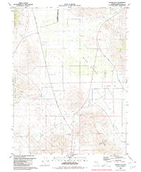 1980 Fraser Flat1980 Print · USGSWashoe County ranching and mining lands are captured here during the late seventies, showing the sparse high-desert landscape. Researchers can trace historic routes like Winnemucca Ranch Road and find sites such as the Ruth Mine and Junction House.3 unique versions available
 - 1980 Map of Reno
 1980 Reno1980 Print · USGSReno and its high-desert surroundings appear in transition during the 1980s, balancing rapid urban expansion with its deep mining and ranching roots. Genealogists and historians can trace the Southern Pacific line through Fernley or locate local landmarks like Mountain View Cem and the Ruth Mine.3 unique versions available
End of results
Showing maps 1-2 of 2
Top cities near Palomino Valley
- Reno historical maps
- Sparks historical maps
- Lemmon Valley historical maps
- Golden Valley historical maps
- Sutcliffe historical maps
Frequently asked questions
- What are the different types of historical maps available for Palomino Valley?
- What is the oldest map of Palomino Valley?
- Where can I purchase historical maps of Palomino Valley for my home or office?
- Where can I download high-res historical maps of Palomino Valley?
- Are there historical topographic maps available for Palomino Valley?
- Is there historical aerial imagery available for Palomino Valley?
- Where are historical maps of Palomino Valley sourced from?