Old Maps of Reno, Nevada
Explore 95 old maps of Reno, spanning from 1890 to today. These high-resolution historic maps reveal how streets, neighborhoods, landmarks, and natural features evolved over time — perfect for genealogy, metal detecting, research, and local history exploration.
What you can do with these maps:
- See how Reno changed over time: Compare historical maps to modern-day views to trace roads, homesites, rail lines & more.
- View detailed metadata: Each map includes creators, publishers, year, scale, and archive source.
- Overlay maps with satellite & LiDAR: Visualize the past alongside modern tools to explore terrain & human change.
- Trusted historical sources: Maps sourced from the USGS, Library of Congress, and other archives.
- Access maps your way: View online, download high-res files, or order prints for personal or research use.
Start exploring old maps of Reno to uncover forgotten places, hidden landmarks, and the deep history beneath your feet.
Reno, NV maps
(95)- 1890 Map of Sierraville, 1955 Print
 1890 Sierraville1955 Print · USGSThe high Sierra Valley and its frontier timber towns are captured here in the late 1800s. Genealogists and historians can trace early rail lines like the Nevada California and Oregon Railway and locate vanished stops and landmarks such as Etta, Purdy, and the Sulphur Spring.
 - 1891 Map of Carson
 1891 Carson1891 Print · USGSSilver mining and rail expansion dominate this late-century look at the Comstock Lode region, from the heights of Virginia to the capital at Carson. Researchers can trace the winding Virginia and Truckee Railroad and locate early sites like Gold Hill, Sutro, and the State Prison.
 - 1891 Map of Truckee
 1891 Truckee1891 Print · USGSThe High Sierra and Lake Tahoe shoreline are captured here in the late nineteenth century as the railroad transformed the mountain economy. Trace the original path of the Central Pacific Railroad through Donner Pass or locate early lakeside landings at Tahoe City and McKinney.
 - 1891 Map of Reno
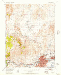
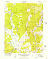
 1891 Reno1891 Print · USGSReno and the high desert valleys of Washoe County were undergoing a rail-driven expansion in the early 1890s. Genealogists and historians can trace early settlements like Poeville and Glendale or follow the path of the Central Pacific Railroad through Truckee Meadows.
 - 1892 Map of Sierraville
 1892 Sierraville1892 Print · USGSSierraville and the high meadows of the eastern Sierras are shown here in the early 1890s, just as the regional rail network was expanding. Genealogists can trace early homesteads and communities like Loyalton, Sattley, and Beckwith, or follow the California Nevada and Oregon Railway as it winds toward the state line.
 - 1893 Map of Carson
 1893 Carson1893 Print · USGSThe Comstock Lode era is in full view here during the 1890s, centering on the silver mining centers and early rail networks of the Nevada territory. Trace the path of the Virginia and Truckee R.R. and locate historic sites like Sutro, Gold Hill, and the State Prison near Carson.9 unique versions available
 - 1893 Map of Truckee
 1893 Truckee1893 Print · USGSHigh Sierra transit and industry dominate this late nineteenth-century landscape as the Central Pacific Railroad crosses the divide. Trace the early footprints of Tahoe City, the remote lodges at Rubicon Springs, and the timber operations around Boca.
 - 1893 Map of Reno
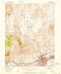
 1893 Reno1893 Print · USGSWashoe and Storey counties come to life in the late nineteenth century as Reno emerges as a major railroad hub. Researchers can trace the early paths of the Central Pacific Railroad and locate vanished outposts like Poeville and Junction House.7 unique versions available
 - 1894 Map of Sierraville
 1894 Sierraville1894 Print · USGSThe high Sierra and Plumas county borderlands are shown in the late nineteenth century as early settlements began to take root in the basin. Researchers can trace the path of the California Nevada and Oregon Railway and locate historic sites like Sierraville, the Fair Grounds, and Loyalton.9 unique versions available
 - 1895 Map of Truckee
 1895 Truckee1895 Print · USGSThe high Sierra and Lake Tahoe's western shore are captured in the late 1800s as the railroad fueled new mountain industry. Trace the historic Central Pacific route past Boca or locate early lakeside spots like McKinney and Rubicon Springs.9 unique versions available
 - 1932 Map of Truckee
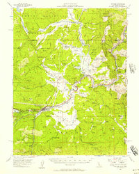
 1932 Truckee1932 Print · USGSThe high Sierra and Lake Tahoe's western shore are captured here in the early thirties as the region balanced industrial mining and timber with a growing seasonal economy. Trace early lakeside developments from Tahoe Tavern to Meeks Bay PO, or locate historical sites like the Walker Mine and Donner Monument.
 - 1940 Map of Truckee
 1940 Truckee1940 Print · USGSThe High Sierra and Lake Tahoe shoreline appear here in the pre-war era, showing a landscape defined by timber, tourism, and transit. Genealogists and historians can trace the early resort development at Tahoe Vista, the lumber works at Hobart Mills, and the vital Southern Pacific rail line.4 unique versions available
 - 1950 Map of Virginia City, 1955 Print
 1950 Virginia City1955 Print · USGSVirginia City and the Comstock mining corridor are seen here at mid-century, amidst a dense concentration of historic shafts and early settlement sites. Researchers can trace the legacy of silver mining through Gold Hill, the Utah Shaft, and several cemeteries that overlook the mountain ranges.3 unique versions available
 - 1950 Map of Mt. Rose, 1956 Print
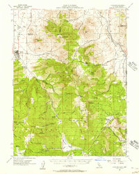
 1950 Mt. Rose1956 Print · USGSMid-century Nevada comes into focus as the Reno area expands south toward the Washoe Valley and the high peaks of the Toiyabe National Forest. Genealogists and historians can trace old homesteads near Franktown, the Ophir Mill Site, and the grounds of the Bowers Mansion.3 unique versions available
 - 1950 Map of Reno, 1957 Print
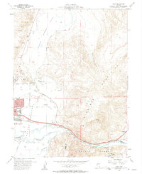
 1950 Reno1957 Print · USGSMid-century Reno and Sparks appear here alongside the vital irrigation networks that sustained the Truckee Meadows. Researchers can trace the development of older neighborhoods and outlying sites like Poeville (Site), the Reno Fair Grounds, and Skyline Airfield.3 unique versions available
 - 1951 Map of Reno
 1951 Reno1951 Print · USGSMid-century Nevada comes into focus as Reno and Sparks expand along the Truckee River and transcontinental rail lines. Trace family history and local industry through features like Mtnview Cem, the Golden Fleece Mine, and early aviation at Skyline Airfield.2 unique versions available
 - 1952 Map of Mt. Rose
 1952 Mt. Rose1952 Print · USGSWashoe County at the start of the 1950s reveals a transition from alpine wilderness to valley ranching and early suburban growth. You can trace historical landmarks like the Ophir Mill Site, Bowers Mansion, and the winding path of the Truckee Ditch.
 - 1952 Map of Virginia City
 1952 Virginia City1952 Print · USGSStorey County's mining heartland is revealed in the mid-century, documenting the legendary Comstock Lode settlements and engineering works. Researchers can trace the massive Sutro Tunnel, locate the Lousetown (Site), and find family roots in Gold Hill or Virginia City.2 unique versions available
 - 1955 Map of Loyalton, 1957 Print
 1955 Loyalton1957 Print · USGSThe Sierra Valley and the high timberlands of the California-Nevada border come alive in the mid-fifties. Genealogists can trace the Loyalton Cem and isolated outposts like Balls Ranch or the Flying Dutchman Mine.4 unique versions available
 - 1955 Map of Truckee, 1957 Print
 1955 Truckee1957 Print · USGSThe High Sierra near the Nevada border comes alive in the mid-fifties as a crossroads of rail history and pioneer memory. Researchers can trace the Southern Pacific Railroad through the canyon to Truckee or locate historic spots like the Joerger Ranch and Hobart Mills.4 unique versions available
 - 1955 Map of Boca, 1957 Print
 1955 Boca1957 Print · USGSThe California-Nevada borderlands in the mid-1950s show a landscape defined by the Truckee River and mountain rail transit. Trace the Southern Pacific line through Floriston, find the Boca Dam spillway, or locate the lookout atop Verdi Peak.7 unique versions available
 - 1957 Map of Vista, 1959 Print
 1957 Vista1959 Print · USGSSparks and the Truckee River corridor are captured during a period of mid-century growth and industrial expansion. Genealogists and local historians can trace the development of neighborhood schools like Lincoln Park Sch or locate the Dominican Brothers Monastery and the railroad stop at Vista.2 unique versions available
 - 1957 Map of Spanish Springs Valley, 1959 Print
 1957 Spanish Springs Valley1959 Print · USGSWashoe County at the end of the fifties shows the transition from historic ranching life to early suburban growth. Genealogists and historians can trace the Southern Pacific corridor through Mustang and Hafed or locate family sites like the Wilcox Ranch and Home Ranch.3 unique versions available
 - 1957 Map of Reno, 1963 Print
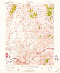
 1957 Reno1963 Print · USGSWestern Nevada in the early sixties is a land of sprawling desert sinks and rising mountain ranges. Genealogists and historians can trace the rail-and-river network connecting Reno, the mining legacy of Rawhide Mine, and the boundaries of the Pyramid Lake Indian Reservation.5 unique versions available
 - 1958 Map of Chico, 1962 Print
 1958 Chico1962 Print · USGSMid-century Northern California comes to life across the Central Valley and high Sierras as the postwar economy transformed the landscape. Trace the rail lines of the Southern Pacific RR, locate family roots near Chico Cem, or explore the early layout of Paradise and Beale Air Force Base.4 unique versions available
Showing maps 1-25 of 95
Top cities near Reno
- Sparks historical maps
- Cold Springs historical maps
- Lemmon Valley historical maps
- Golden Valley historical maps
- Mogul historical maps
Top neighborhoods of Reno
- Stead historical maps
- Bella Vista Ranch historical maps
- Discovery Village historical maps
- Donner Springs historical maps
- Edgewater historical maps
- Midtown historical maps
See more
Frequently asked questions
- What are the different types of historical maps available for Reno?
- What is the oldest map of Reno?
- Where can I purchase historical maps of Reno for my home or office?
- Where can I download high-res historical maps of Reno?
- Are there historical topographic maps available for Reno?
- Is there historical aerial imagery available for Reno?
- Where are historical maps of Reno sourced from?