1970s Maps of Reno, Nevada
Explore 7 historic maps of Reno from the 1970s. These maps offer a rare glimpse into what life looked like during the 1970s — showing old roads, neighborhoods, homes, and landmarks that have changed or disappeared over time.
Whether you're researching your family's past, planning a metal detecting trip, or studying how Reno's landscape evolved across the 1970s, these high-resolution maps are a powerful tool for exploring the history of this region.
- Focus on a specific era: All maps on this page are from the 1970s, giving you a focused view of this time period.
- See what’s changed: Compare century-old streets, trails, and buildings to today's modern landscape using overlays and satellite layers.
- Research with precision: Use these maps for genealogy, historical research, land use analysis, or educational projects.
- View, download, or print: Maps are fully viewable online in high resolution, and can be downloaded or printed for your own records.
Start exploring Reno's history through authentic maps from the 1970s. This is your window into the past.
Reno, NV maps
(7)- 1974 Map of Reno, 1976 Print
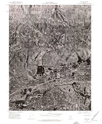 1974 Reno1976 Print · USGSNorthern Nevada during the mid-seventies comes into sharp focus in this aerial study of the growing Reno-Sparks area. Trace the urban sprawl and early infrastructure surrounding Reno, Sparks, and the winding Truckee River.
 - 1974 Map of Mt. Rose NE, 1977 Print
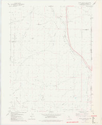
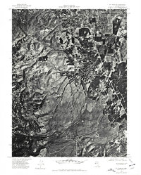 1974 Mt. Rose NE1977 Print · USGSThe southern fringes of Reno meet the high desert in the mid-1970s, showcasing a landscape in the midst of suburban expansion. Researchers can trace the natural drainage of Evans Creek and Thomas Creek as they flow toward the Truckee Meadows.
 - 1975 Map of Vista, 1977 Print
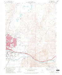 1975 Vista1977 Print · USGSMid-century Nevada expansion is evident here as the city of Sparks reaches toward the Pah Rah Range. Researchers can trace the mid-seventies landscape of schools like Reed High Sch, agricultural sites like the University of Nevada Farm, and small outposts such as Mustang.4 unique versions available
 - 1977 Map of Truckee, 1978 Print
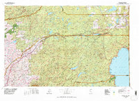 1977 Truckee1978 Print · USGSThe High Sierra and Lake Tahoe regions come into focus in the late seventies, showing a landscape defined by massive reservoir projects and mountain transit. Genealogists and historians can trace the Southern Pacific rail line through Truckee or explore old mining districts near North Bloomfield and Colfax.2 unique versions available
 - 1978 Map of Evans Canyon
 1978 Evans Canyon1978 Print · USGSThe high-desert ranching country of the Sierra-Nevada border is captured here in the late seventies. Researchers can trace the Western Pacific rail line through Long Valley or locate local landmarks like Balls Ranch and Purdy.2 unique versions available
 - 1979 Map of Carson City, 1980 Print
 1979 Carson City1980 Print · USGSWestern Nevada in the late seventies reveals a landscape of historic mining districts and expanding mountain communities. Researchers can trace the Comstock Lode through Virginia City, locate the Stewart Indian School, or explore the shores of Lake Tahoe near Incline Village.2 unique versions available
 - 1979 Map of Portola, 1993 Print
 1979 Portola1993 Print · USGSThe northern Sierra Nevada and its timber-and-rail economy are captured here during the late seventies, spanning from the Feather River canyons to the high basins. Researchers can trace the path of the Western Pacific RR and locate historic hubs like Quincy, Portola, and Loyalton.2 unique versions available
End of results
Showing maps 1-7 of 7
Top cities near Reno
- Sparks historical maps
- Cold Springs historical maps
- Lemmon Valley historical maps
- Golden Valley historical maps
- Mogul historical maps
Top neighborhoods of Reno
- Stead historical maps
- Bella Vista Ranch historical maps
- Discovery Village historical maps
- Donner Springs historical maps
- Edgewater historical maps
- Midtown historical maps
See more
Frequently asked questions
- What are the different types of historical maps available for Reno?
- What is the oldest map of Reno?
- Where can I purchase historical maps of Reno for my home or office?
- Where can I download high-res historical maps of Reno?
- Are there historical topographic maps available for Reno?
- Is there historical aerial imagery available for Reno?
- Where are historical maps of Reno sourced from?