1960s Maps of Reno, Nevada
Explore 10 historic maps of Reno from the 1960s. These maps offer a rare glimpse into what life looked like during the 1960s — showing old roads, neighborhoods, homes, and landmarks that have changed or disappeared over time.
Whether you're researching your family's past, planning a metal detecting trip, or studying how Reno's landscape evolved across the 1960s, these high-resolution maps are a powerful tool for exploring the history of this region.
- Focus on a specific era: All maps on this page are from the 1960s, giving you a focused view of this time period.
- See what’s changed: Compare century-old streets, trails, and buildings to today's modern landscape using overlays and satellite layers.
- Research with precision: Use these maps for genealogy, historical research, land use analysis, or educational projects.
- View, download, or print: Maps are fully viewable online in high resolution, and can be downloaded or printed for your own records.
Start exploring Reno's history through authentic maps from the 1960s. This is your window into the past.
Reno, NV maps
(10)- 1960 Map of Reno
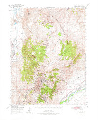
 1960 Reno1960 Print · USGSThe high desert of western Nevada comes alive in this mid-century survey of the Reno-Tahoe region. Genealogists and historians can trace rail lines like the Southern Pacific RR and locate remote outposts such as Olinghouse, Nixon, and the Olinghouse Mine.2 unique versions available
 - 1960 Map of Chico
 1960 Chico1960 Print · USGSThe Northern California high country and Sacramento Valley meet in this 1960s-era landscape of mining towns and river settlements. Trace the rail-and-water economy of the gold country through the Empire Mine, Beale Air Force Base, and the Western Pacific Railroad.
 - 1960 Map of Virginia City, 1976 Print
 1960 Virginia City1976 Print · USGSThe Comstock Lode is shown in detail at mid-century, mapping the industrial footprint of the silver mining boom. Genealogists and historians can locate mining infrastructure, the Sutro Tunnel, and settlements like Gold Hill, Silver City, and American Flat.
 - 1967 Map of Verdi, 1970 Print
 1967 Verdi1970 Print · USGSWashoe County at the height of the late sixties reveals a landscape of transit and mining legacy along the California-Nevada border. Trace the historic Southern Pacific rail lines through Verdi and identify old workings like the Red Metal Mine or the Poeveille (Site).5 unique versions available
 - 1967 Map of Reno NE, 1970 Print
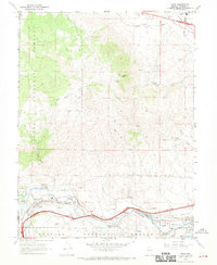
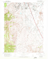
 1967 Reno NE1970 Print · USGSThe northern reaches of the Truckee Meadows show a period of rapid mid-century growth near the Reno-Stead Airport. Researchers can trace the development of Lemmon Valley through its state-named streets, the Lemmon Valley Sch, and numerous local Sandpit sites.4 unique versions available
 - 1967 Map of Steamboat, 1971 Print
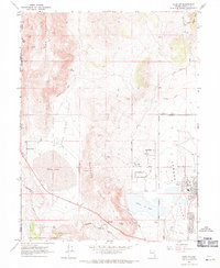
 1967 Steamboat1971 Print · USGSWashoe and Storey counties meet along the rugged Virginia Range during the late sixties, where mining prospects and ranching roads intersect. Genealogists and researchers can locate Washington (Site), the Brown-Washoe Sch No 3, and the Castle Peak Mine.4 unique versions available
 - 1967 Map of Reno, 1971 Print
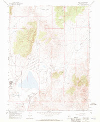
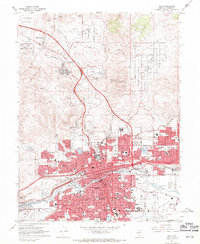 1967 Reno1971 Print · USGSReno and Sparks appear in the late sixties as the Truckee River valley transforms into a major regional hub. Genealogists and local historians can trace family neighborhoods, schools like Maxwell Sch, and landmarks including the Reno-Sparks Indian Colony and Mountain View Cem.4 unique versions available
 - 1967 Map of Reno NW, 1971 Print
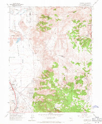
 1967 Reno NW1971 Print · USGSThe Nevada-California borderlands near Reno emerge in the late sixties as aviation and rail hubs. Trace the layout of Reno-Stead Airport or locate old mining sites like the Antelope Mine and Copperfield along the Western Pacific line.4 unique versions available
 - 1968 Map of Mt. Rose NW, 1972 Print
 1968 Mt. Rose NW1972 Print · USGSThe eastern front of the Carson Range comes into focus in the late 1960s, showing the high-altitude water systems and rail lines west of Reno. Researchers can trace the path of the Southern Pacific and locate mountain landmarks like Hunter Lake and Big Meadows Springs.5 unique versions available
 - 1969 Map of Mt. Rose NE, 1972 Print
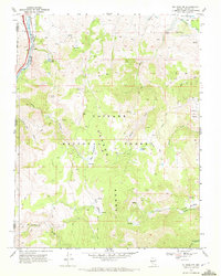
 1969 Mt. Rose NE1972 Print · USGSReno's southern expansion and the surrounding ranch lands are captured here just as the suburban footprint began to reshape the Truckee Meadows in the late sixties. Researchers can trace the intersection of early irrigation at Steamboat Ditch with landmarks like Wheeler Ranch and the Reno Municipal Airport.4 unique versions available
End of results
Showing maps 1-10 of 10
Top cities near Reno
- Sparks historical maps
- Cold Springs historical maps
- Lemmon Valley historical maps
- Golden Valley historical maps
- Mogul historical maps
Top neighborhoods of Reno
- Stead historical maps
- Bella Vista Ranch historical maps
- Discovery Village historical maps
- Donner Springs historical maps
- Edgewater historical maps
- Midtown historical maps
See more
Frequently asked questions
- What are the different types of historical maps available for Reno?
- What is the oldest map of Reno?
- Where can I purchase historical maps of Reno for my home or office?
- Where can I download high-res historical maps of Reno?
- Are there historical topographic maps available for Reno?
- Is there historical aerial imagery available for Reno?
- Where are historical maps of Reno sourced from?