1900s (20th Century) Maps of Pyramid, Nevada
Explore 4 historic maps of Pyramid from the 1900s (20th Century). These maps offer a rare glimpse into what life looked like during the 1900s — showing old roads, neighborhoods, homes, and landmarks that have changed or disappeared over time.
Whether you're researching your family's past, planning a metal detecting trip, or studying how Pyramid's landscape evolved across the 1900s, these high-resolution maps are a powerful tool for exploring the history of this region.
- Focus on a specific era: All maps on this page are from the 1900s, giving you a focused view of this time period.
- See what’s changed: Compare century-old streets, trails, and buildings to today's modern landscape using overlays and satellite layers.
- Research with precision: Use these maps for genealogy, historical research, land use analysis, or educational projects.
- View, download, or print: Maps are fully viewable online in high resolution, and can be downloaded or printed for your own records.
Start exploring Pyramid's history through authentic maps from the 1900s. This is your window into the past.
Pyramid, NV maps
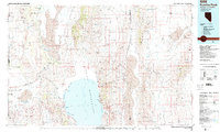
(4)- 1955 Map of Lovelock, 1963 Print
 1955 Lovelock1963 Print · USGSNorthwestern Nevada’s vast desert basins and military ranges are captured here in the mid-fifties, showing a landscape defined by the Humboldt River and the great Pyramid Lake. Genealogists and historians can trace isolated rail stops like Gerlach and Empire, or locate historic workings such as the Golden Eagle Mine and Pershing Mine.5 unique versions available
 - 1959 Map of Lovelock
 1959 Lovelock1959 Print · USGSNorthwestern Nevada in the late fifties is a study in vast desert basins and isolated rail outposts like Gerlach and Sulphur. You can trace the Humboldt River corridor through Lovelock, identify mid-century military zones, and locate the Mine Mill in the northern ranges.2 unique versions available
 - 1964 Map of Pyramid SW, 1966 Print
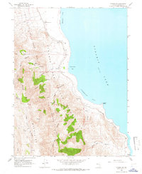 1964 Pyramid SW1966 Print · USGSThe western shores of Pyramid Lake are captured here in the mid-1960s, showing the rugged interface of the Virginia Mountains and the desert water. Trace the Southern Pacific rail line past Big Canyon Ranch, Thunderbolt Bay, and Warrior Point.2 unique versions available
 - 1984 Map of Kumiva Peak
 1984 Kumiva Peak1984 Print · USGSThe high desert of Washoe and Pershing counties is captured here in the mid-1980s, centered on the stark beauty of the Pyramid Lake basin. Researchers can trace the dual rail lines of the Southern Pacific and Western Pacific as they navigate the Sand Pass and the edges of the Smoke Creek Desert.
End of results
Showing maps 1-4 of 4
Top cities near Pyramid
Frequently asked questions
- What are the different types of historical maps available for Pyramid?
- What is the oldest map of Pyramid?
- Where can I purchase historical maps of Pyramid for my home or office?
- Where can I download high-res historical maps of Pyramid?
- Are there historical topographic maps available for Pyramid?
- Is there historical aerial imagery available for Pyramid?
- Where are historical maps of Pyramid sourced from?