1900s (20th Century) Maps of Reederville, Nevada
Explore 5 historic maps of Reederville from the 1900s (20th Century). These maps offer a rare glimpse into what life looked like during the 1900s — showing old roads, neighborhoods, homes, and landmarks that have changed or disappeared over time.
Whether you're researching your family's past, planning a metal detecting trip, or studying how Reederville's landscape evolved across the 1900s, these high-resolution maps are a powerful tool for exploring the history of this region.
- Focus on a specific era: All maps on this page are from the 1900s, giving you a focused view of this time period.
- See what’s changed: Compare century-old streets, trails, and buildings to today's modern landscape using overlays and satellite layers.
- Research with precision: Use these maps for genealogy, historical research, land use analysis, or educational projects.
- View, download, or print: Maps are fully viewable online in high resolution, and can be downloaded or printed for your own records.
Start exploring Reederville's history through authentic maps from the 1900s. This is your window into the past.
Reederville, NV maps
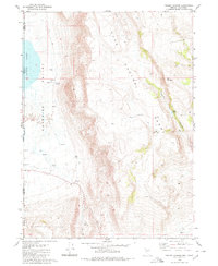
(5)- 1954 Map of Vya, 1967 Print
 1954 Vya1967 Print · USGSThe tri-state corner of Nevada, Oregon, and California appears here in the mid-fifties, dominated by wildlife refuges and massive naval gunnery ranges. Trace isolated high-desert outposts like Vya and Soldier Meadow Ranch or find historic workings at the Ashdown Mine.3 unique versions available
 - 1958 Map of Vya
 1958 Vya1958 Print · USGSNorthwest Nevada and the tri-state border region are mapped here during the mid-fifties, showing a remote landscape of high desert ranches and sprawling antelope range. Trace historic operations like the Ashdown Mine, find local camps like Coyote Camp, and locate isolated outposts from Vya to Denio.2 unique versions available
 - 1962 Map of Vya
 1962 Vya1962 Print · USGSThe Nevada and Oregon borderlands in the early sixties reveal a landscape of isolated ranching outposts and high-desert mining. Researchers can trace historic family holdings like the Denio Ranch or locate early mineral sites including the Mcadoo Mine and Iron King Mine.
 - 1980 Map of Pegleg Canyon
 1980 Pegleg Canyon1980 Print · USGSThe California-Nevada borderlands are captured in the early eighties as a landscape of remote ranching and rugged desert hydrology. Trace early water rights and land use at the Murphy Ranch, Pegleg Reservoir, and a geothermal Spring (Hot).
 - 1981 Map of High Rock Canyon
 1981 High Rock Canyon1981 Print · USGSNorthwestern Nevada at the dawn of the eighties remains a landscape of remote outposts and dramatic geological shifts. Genealogists and historians can trace the sites of Leadville, isolated features like Powers Well, and the vast boundaries of the Black Rock Desert.2 unique versions available
End of results
Showing maps 1-5 of 5
Top cities near Reederville
Frequently asked questions
- What are the different types of historical maps available for Reederville?
- What is the oldest map of Reederville?
- Where can I purchase historical maps of Reederville for my home or office?
- Where can I download high-res historical maps of Reederville?
- Are there historical topographic maps available for Reederville?
- Is there historical aerial imagery available for Reederville?
- Where are historical maps of Reederville sourced from?